Home > Europe > United Kingdom > England > Essex > Grays
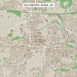
Clacton-on-Sea Essex UK City Street Map

![]()
Wall Art and Photo Gifts from Fine Art Storehouse
Clacton-on-Sea Essex UK City Street Map
Vector Illustration of a City Street Map of Clacton-on-Sea, Essex, UK. Included files are EPS (v10) and Hi-Res JPG.
Data courtesy from Ordnance Survey: VectorMap District
https:/ordnancesurvey.co.uk/business-and-government/products/vectormap-district.html
OS OpenData is free to use under the Open Government Licence (OGL).
Contains OS data eCrown copyright and database right 2017.
http:/nationalarchives.gov.uk/doc/open-government-licence/version/3/
Unleash your creativity and transform your space into a visual masterpiece!
Frank Ramspott
Media ID 15055193
© Frank Ramspott, all rights reserved
Aerial View Computer Graphic Directly Above Essex Gray Green North Sea Port Road Map Street Map Text Clacton On Sea Digitally Generated Image
FEATURES IN THESE COLLECTIONS
> Aerial Photography
> Related Images
> Arts
> Contemporary art
> Digital artwork
> Street art
> Arts
> Portraits
> Pop art gallery
> Street art portraits
> Arts
> Street art graffiti
> Digital art
> Digital paintings
> Arts
> Street art graffiti
> Digital art
> Vector illustrations
> Europe
> United Kingdom
> England
> Essex
> Clacton-on-Sea
> Europe
> United Kingdom
> England
> Essex
> Clacton on Sea
> Europe
> United Kingdom
> England
> Essex
> Grays
> Europe
> United Kingdom
> England
> Essex
> Related Images
> Europe
> United Kingdom
> Maps
> Fine Art Storehouse
> Map
> Street Maps
EDITORS COMMENTS
This print showcases a detailed and intricate city street map of Clacton-on-Sea, Essex, UK. The vector illustration beautifully captures the essence of this charming coastal town, highlighting its unique features and layout. Created using EPS (v10) and Hi-Res JPG files, this artwork is a testament to the skillful craftsmanship of Frank Ramspott. The data used in creating this masterpiece is courtesy of Ordnance Survey: VectorMap District, ensuring accuracy and reliability. OS OpenData has been utilized under the Open Government Licence (OGL), emphasizing its free accessibility for all users. It's important to note that this image contains OS data eCrown copyright and database right 2017. From the stunning coastline along the North Sea to the bustling streets adorned with buildings, every element on this map comes together seamlessly. The design exudes a sense of cartography expertise while incorporating modern digital techniques. With no people present in the image, it allows viewers to focus solely on appreciating the artistry behind this visually striking composition. The color palette consists of shades of gray, green, blue, and white which perfectly complement each other. Whether you're an admirer of maps or simply appreciate fine art photography that captures physical geography from an aerial perspective directly above - this print will surely captivate your imagination.
MADE IN THE USA
Safe Shipping with 30 Day Money Back Guarantee
FREE PERSONALISATION*
We are proud to offer a range of customisation features including Personalised Captions, Color Filters and Picture Zoom Tools
SECURE PAYMENTS
We happily accept a wide range of payment options so you can pay for the things you need in the way that is most convenient for you
* Options may vary by product and licensing agreement. Zoomed Pictures can be adjusted in the Cart.