Home > Asia > Japan > Maps
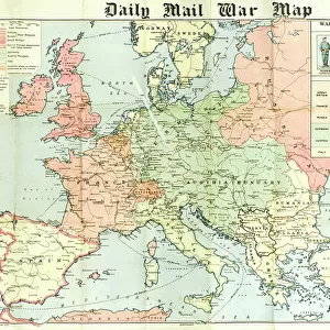
Map of the theatre of the Russo-Japanese War, 1904. Artist: A Meunier

![]()
Wall Art and Photo Gifts from Heritage Images
Map of the theatre of the Russo-Japanese War, 1904. Artist: A Meunier
Map of the theatre of the Russo-Japanese War, 1904. The Russo-Japanese War arose due to the two countries conflicting territorial ambitions in East Asia. When the Russians reneged on an agreement to withdraw troops from Manchuria, the Japanese embarked on a lengthy siege of the Russian-leased city of Port Arthur in Manchuria. Port Arthur surrendered in January 1905, and a combination of incompetence on the part of Russian commanders and the decisive victory for the Japanese navy at the Battle of Tsushima forced the Russians to the negotiating table. The outcome of the war was Japan gaining effective control of Korea and much of Manchuria. An illustration from Le Petit Journal, 28th February 1904
Heritage Images features heritage image collections
Media ID 14881778
© Artmedia / Heritage-Images
Cartography Korea Manchuria Map Making Meunier Print Collector5 Russo Japanese War
FEATURES IN THESE COLLECTIONS
> Arts
> Artists
> Related Images
> Asia
> Japan
> Related Images
> Europe
> Russia
> Related Images
> Historic
> Battles
> Related Images
> Maps and Charts
> Related Images
> Services
> Royal Navy
EDITORS COMMENTS
This print showcases a detailed "Map of the theatre of the Russo-Japanese War, 1904" created by artist A Meunier. The map vividly depicts the territorial ambitions and conflicts between Russia and Japan in East Asia during that time. At the heart of this war was Russia's failure to withdraw troops from Manchuria as agreed upon, leading to a prolonged siege of Port Arthur by Japanese forces. The surrender of Port Arthur in January 1905 marked a turning point in the conflict, exposing Russian commanders' incompetence and highlighting the decisive victory achieved by the Japanese navy at the Battle of Tsushima. These events forced Russia to come to terms with Japan at the negotiating table. Ultimately, Japan emerged triumphant from this war, gaining effective control over Korea and significant portions of Manchuria. This historical illustration from Le Petit Journal on February 28th, 1904 provides valuable insight into these geopolitical shifts during that era. With its vibrant colors and meticulous cartography, this artwork serves as both an informative tool for understanding past conflicts and a testament to A Meunier's skillful map-making abilities. It stands as a reminder of how territorial disputes can shape history while also showcasing art's power to convey complex concepts visually.
MADE IN THE USA
Safe Shipping with 30 Day Money Back Guarantee
FREE PERSONALISATION*
We are proud to offer a range of customisation features including Personalised Captions, Color Filters and Picture Zoom Tools
SECURE PAYMENTS
We happily accept a wide range of payment options so you can pay for the things you need in the way that is most convenient for you
* Options may vary by product and licensing agreement. Zoomed Pictures can be adjusted in the Cart.