Home > Arts > Landscape paintings > Landscape art > Landscape paintings
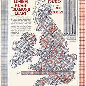
The Illustrated London News Election Map - 1906

![]()
Wall Art and Photo Gifts from Mary Evans Picture Library
The Illustrated London News Election Map - 1906
The Illustrated London News Election Map - 1906 - The electoral battlefield at a glance: Candidates and Constituencies by A Hugh Fisher. Date: 1906
Mary Evans Picture Library makes available wonderful images created for people to enjoy over the centuries
Media ID 19729418
© Illustrated London News Ltd/Mary Evans
Battlefield Candidate Circles Constituencies Constituency Election Electoral Fisher Hugh Layout News Parliament Politicians Representation Voting
FEATURES IN THESE COLLECTIONS
> Arts
> Landscape paintings
> Landscape art
> Landscape paintings
> Europe
> United Kingdom
> England
> London
> Politics
> Related Images
> Maps and Charts
> Related Images
> People
> Politicians
EDITORS COMMENTS
This print, titled "The Illustrated London News Election Map - 1906" by A. Hugh Fisher, offers a fascinating glimpse into the political landscape of the United Kingdom during a pivotal moment in its history. The map, published by The Illustrated London News, provides an intricately detailed overview of the electoral battlefield that unfolded during the 1906 General Election. The map is a visual representation of the constituencies and their respective candidates, each circle on the map signifying a constituency, with the size of the circle indicating the magnitude of the electoral district's population. The map is adorned with the names of the candidates and their political affiliations, providing an at-a-glance understanding of the political composition of each constituency. The 1906 General Election was a significant event in British politics, marking the Liberal Party's landslide victory under the leadership of Prime Minister Henry Campbell-Bannerman. The election resulted in a substantial increase in the number of Liberal MPs, as well as the Labour Party's first representation in the House of Commons. This map serves as an essential historical document, illustrating the political makeup of the country during a time of significant change. The intricate layout, with its meticulous attention to detail, offers a captivating window into the political landscape of the early 1900s. The map's design, with its clear and concise representation of candidates and constituencies, provides a valuable resource for scholars, historians, and anyone interested in the intricacies of British politics during this period.
MADE IN THE USA
Safe Shipping with 30 Day Money Back Guarantee
FREE PERSONALISATION*
We are proud to offer a range of customisation features including Personalised Captions, Color Filters and Picture Zoom Tools
SECURE PAYMENTS
We happily accept a wide range of payment options so you can pay for the things you need in the way that is most convenient for you
* Options may vary by product and licensing agreement. Zoomed Pictures can be adjusted in the Cart.