Home > Architecture > Industrial
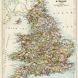
Map, South Wales coalfield

![]()
Wall Art and Photo Gifts from Mary Evans Picture Library
Map, South Wales coalfield
Map, South Wales coalfield.
1939
Mary Evans Picture Library makes available wonderful images created for people to enjoy over the centuries
Media ID 23109200
© Mary Evans Picture Library
Boundary Bristol Cardiff Channel Coal Collieries Colliery Mines Mining Newport Swansea Coalfield
FEATURES IN THESE COLLECTIONS
> Europe
> France
> Canton
> Landes
> Europe
> United Kingdom
> England
> Bristol
> Bristol
> Europe
> United Kingdom
> Maps
> Europe
> United Kingdom
> Wales
> Cardiff
> Europe
> United Kingdom
> Wales
> Gwent
> Newport
> Europe
> United Kingdom
> Wales
> Maps
> Europe
> United Kingdom
> Wales
> Newport
> Europe
> United Kingdom
> Wales
> Pembrokeshire
> Newport
> Europe
> United Kingdom
> Wales
> Posters
> Mary Evans Prints Online
> New Images August 2021
EDITORS COMMENTS
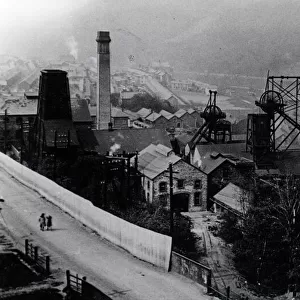
This historic map print, dated 1939, offers a fascinating glimpse into the South Wales Coalfield during the height of the coal mining industry in the 1930s. The intricately detailed map illustrates the extensive network of collieries, pits, and mines that sprawled across the region, with the Bristol Channel and the surrounding land forming the boundary. The South Wales Coalfield, located in southern Wales and southwest England, was a major center of coal production in the UK during the 19th and 20th centuries. The industry played a crucial role in the region's economy and social fabric, providing employment opportunities for thousands of people. The map reveals the location of numerous collieries and pits, including those in Newport, Cardiff, and Swansea. The intricate details of the map also highlight the complex system of railways and tramways that connected the mines to the ports, enabling the efficient transportation of coal to markets both domestically and abroad. The map also shows the proximity of the coal mines to the sea, with the Bristol Channel forming a significant part of the boundary. The channel was an important transportation route for coal, with many collieries located close to the coast. This map provides a valuable record of the South Wales Coalfield during a period of significant industrial activity. It offers insights into the scale and complexity of the coal mining industry, as well as the impact it had on the region's landscape and communities. The map is a testament to the rich industrial heritage of South Wales and the important role it played in the UK's industrial history.
MADE IN THE USA
Safe Shipping with 30 Day Money Back Guarantee
FREE PERSONALISATION*
We are proud to offer a range of customisation features including Personalised Captions, Color Filters and Picture Zoom Tools
SECURE PAYMENTS
We happily accept a wide range of payment options so you can pay for the things you need in the way that is most convenient for you
* Options may vary by product and licensing agreement. Zoomed Pictures can be adjusted in the Cart.