Home > Europe > United Kingdom > England > London > Towns > Blackwall
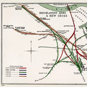
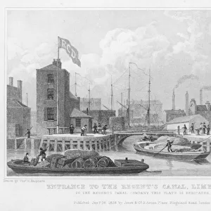
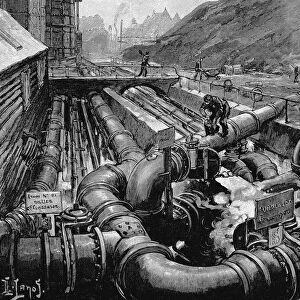
Map, Tom Manns Dock Scheme, London

![]()
Wall Art and Photo Gifts from Mary Evans Picture Library
Map, Tom Manns Dock Scheme, London
Map, Tom Manns Dock Scheme, London.
1892
Mary Evans Picture Library makes available wonderful images created for people to enjoy over the centuries
Media ID 23109206
© Mary Evans Picture Library
1892 Blackwall Dock Docks Export Greenwich Limehouse Mann Reach Scheme December
FEATURES IN THESE COLLECTIONS
> Arts
> Landscape paintings
> Waterfall and river artworks
> River artworks
> Europe
> United Kingdom
> England
> London
> Boroughs
> Greenwich
> Europe
> United Kingdom
> England
> London
> Related Images
> Europe
> United Kingdom
> England
> London
> River Thames
> Europe
> United Kingdom
> England
> London
> Towns
> Blackwall
> Europe
> United Kingdom
> England
> London
> Towns
> Greenwich
> Europe
> United Kingdom
> England
> London
> Towns
> Limehouse
> Maps and Charts
> Related Images
> Mary Evans Prints Online
> New Images August 2021
EDITORS COMMENTS
This map print, titled "Map, Tom Manns Dock Scheme, London," dates back to December 1892, offering a fascinating glimpse into the late Victorian era's maritime infrastructure. The map, published by an unknown cartographer, illustrates the Tom Manns Dock Scheme, which was a significant expansion project for the London Docks, located along the River Thames. The map meticulously details the various docks and reaches, including Blackwall Reach, Greenwich Reach, and Limehouse Reach, that were integral parts of the Tom Manns Dock Scheme. These docks played a crucial role in the import and export industries, contributing significantly to London's economic growth during the late 1800s. The map also highlights the intricate network of canals and locks that connected the docks to the Thames, allowing for the efficient movement of goods between ships and warehouses. The Tom Manns Dock Scheme was a testament to the engineering prowess of the late Victorian era, demonstrating the ability to transform the natural landscape to accommodate the needs of commerce and industry. The map's intricate details and clear labeling make it an essential resource for historians, urban planners, and anyone interested in the history of London's maritime past. The Tom Manns Dock Scheme was a vital component of London's maritime infrastructure during the 1890s and played a significant role in the city's economic development. This map print offers a unique perspective on this fascinating period in London's history.
MADE IN THE USA
Safe Shipping with 30 Day Money Back Guarantee
FREE PERSONALISATION*
We are proud to offer a range of customisation features including Personalised Captions, Color Filters and Picture Zoom Tools
SECURE PAYMENTS
We happily accept a wide range of payment options so you can pay for the things you need in the way that is most convenient for you
* Options may vary by product and licensing agreement. Zoomed Pictures can be adjusted in the Cart.