Home > Universal Images Group (UIG) > Art > Painting, Sculpture & Prints > Cartography
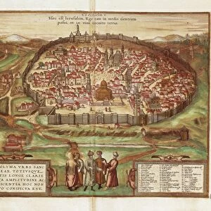
Map of city, from Civitates Orbis Terrarum by Georg Braun, 1541-1622 and Franz Hogenberg, 1540-1590, engraving

![]()
Wall Art and Photo Gifts from Universal Images Group (UIG)
Map of city, from Civitates Orbis Terrarum by Georg Braun, 1541-1622 and Franz Hogenberg, 1540-1590, engraving
Cartography, Netherlands, 16th century. Map of Amsterdam. From Civitates Orbis Terrarum by Georg Braun (1541-1622) and Franz Hogenberg (1540-1590), Cologne. Engraving
Universal Images Group (UIG) manages distribution for many leading specialist agencies worldwide
Media ID 9571769
© DEA / R. MERLO
16th Century Abundance Aerial View Border Canal Capital Cities City Cityscape Coastline Coat Of Arms Franz Hogenberg Georg Braun Guidance Harbor Human Settlement Insignia Nautical Vessel Navigational Equipment Old Town Period Costume River Road Sailing Ship Ship Text Traditional Clothing Transportation Two People Western Script
EDITORS COMMENTS
This print showcases a remarkable piece of cartographic history, a Map of Amsterdam from the renowned Civitates Orbis Terrarum by Georg Braun and Franz Hogenberg. Created in the 16th century in Cologne, this engraving provides an intricate depiction of the city's topography and architectural splendor. The map unfolds before our eyes, revealing a bustling cityscape with its old town charm and abundance of transportation options. The detailed illustrations include men dressed in traditional clothing, sailing ships gracefully navigating the sea, and navigational equipment that guided explorers during that era. Amsterdam's rich maritime heritage is beautifully captured as a ship stands proudly at its harbor while canals weave through the city like lifelines connecting various neighborhoods. The coat of arms adorns the borders, symbolizing civic pride and identity. As we delve into this historical masterpiece, it becomes evident how artfully engraved images were used to convey not only geographical information but also cultural significance. Western script text accompanies key landmarks on the map, offering guidance to travelers exploring this vibrant capital city. Transporting us back in time with its period costumes and architecture, this aerial view allows us to appreciate Amsterdam's evolution over centuries. It serves as a testament to human settlement along coastlines and celebrates both artistic craftsmanship and advancements in cartography. This print is truly an invaluable treasure for those passionate about history, art enthusiasts seeking inspiration or anyone captivated by Amsterdam's timeless allure.
MADE IN THE USA
Safe Shipping with 30 Day Money Back Guarantee
FREE PERSONALISATION*
We are proud to offer a range of customisation features including Personalised Captions, Color Filters and Picture Zoom Tools
SECURE PAYMENTS
We happily accept a wide range of payment options so you can pay for the things you need in the way that is most convenient for you
* Options may vary by product and licensing agreement. Zoomed Pictures can be adjusted in the Cart.