Home > Architecture > Country > France
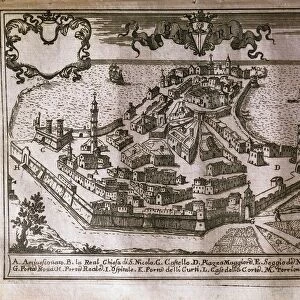
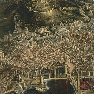
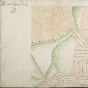
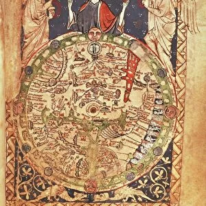
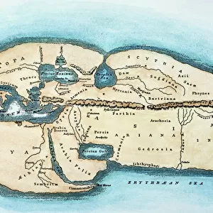
Map of Mont-Dauphin, from, Cartes des environs de Plusieurs places, watercolor drawing, circa 1700

![]()
Wall Art and Photo Gifts from Universal Images Group (UIG)
Map of Mont-Dauphin, from, Cartes des environs de Plusieurs places, watercolor drawing, circa 1700
Cartography. France, 18th century. Map of Mont-Dauphin. From " Cartes des environs de Plusieurs places...", atlas of fortifications made for Louis XIV, 1700 ca. Watercolor drawing. 46 x 53 cm
Universal Images Group (UIG) manages distribution for many leading specialist agencies worldwide
Media ID 9572733
© DEA PICTURE LIBRARY
18th Century City Direction Guidance Mountain Range River Valley Western Script Non Urban Scene
FEATURES IN THESE COLLECTIONS
> Architecture
> Country
> France
> Architecture
> Drawings
> Arts
> Art Movements
> Landscapes
> Arts
> Contemporary art
> Landscapes
> Sculptures
> Arts
> Contemporary art
> Sculpture
> Landscape paintings
> Arts
> Landscape paintings
> Landscape art
> Landscape paintings
> Arts
> Landscape paintings
> Landscape art
> Arts
> Landscape paintings
> Waterfall and river artworks
> Landscape paintings
> Arts
> Landscape paintings
> Waterfall and river artworks
> River artworks
> Universal Images Group (UIG)
> Art
> Painting, Sculpture & Prints
> Illustration And Painting
EDITORS COMMENTS
This print showcases a stunning watercolor drawing of the Map of Mont-Dauphin, dating back to the 18th century. The map is part of the renowned "Cartes des environs de Plusieurs places" atlas, commissioned by Louis XIV himself. Measuring 46 x 53 cm, this horizontal masterpiece provides a glimpse into the rich history and architectural marvels of Mont-Dauphin. The intricate details captured in this watercolor drawing offer valuable guidance for travelers and historians alike. With its precise depiction of the city's layout, surrounding landscape, and physical geography, it serves as a reliable source for understanding the region during that era. Mont-Dauphin's strategic location amidst mountain ranges and along a river is beautifully illustrated in this artwork. The absence of people allows viewers to focus solely on appreciating its awe-inspiring architecture and non-urban scene. The use of western script adds an element of authenticity to this historical artifact. Its vibrant colors bring life to every stroke, making it an exquisite example of artistry combined with cartography. As we gaze upon this remarkable piece from centuries past, we are transported back in time to experience Mont-Dauphin as it once was—a testament to human ingenuity nestled within nature's embrace.
MADE IN THE USA
Safe Shipping with 30 Day Money Back Guarantee
FREE PERSONALISATION*
We are proud to offer a range of customisation features including Personalised Captions, Color Filters and Picture Zoom Tools
SECURE PAYMENTS
We happily accept a wide range of payment options so you can pay for the things you need in the way that is most convenient for you
* Options may vary by product and licensing agreement. Zoomed Pictures can be adjusted in the Cart.