Home > Northern renaissance paintings
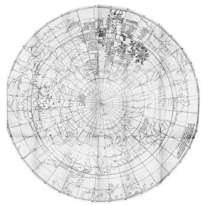
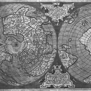
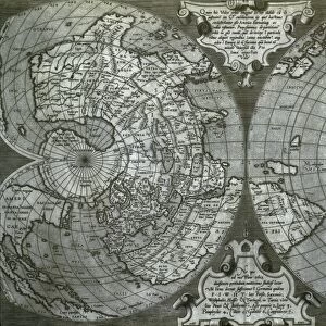
Totius Orbis Cogniti Universalis Descriptio, Antwerp, 1593 (engraving)
")
![]()
Wall Art and Photo Gifts from Fine Art Finder
Totius Orbis Cogniti Universalis Descriptio, Antwerp, 1593 (engraving)
3554905 Totius Orbis Cogniti Universalis Descriptio, Antwerp, 1593 (engraving) by Jode, Cornelis de (1568-1600); 45.1x59.2 cm; Private Collection; (add.info.: Dated 1589 (but 1593)
Engraved world map, on a rectangular projection, image 360 x 508 mm (451 x 592 mm sheet). Surmounted by the title set in a framed cartouche, with two small hemisphere maps at each of the upper corners, Latin text on verso. (Very light browning along edges, short marginal tear to fold repaired on verso.) Matted and framed.
Second edition from de Jodes Speculum Orbis Terrarum issued in 1593. The map was drawn up by Cornelis in November 1589, and printed by his father Gerard. The first edition of the Speculum was published by Gerard in 1587, in competition with Orteliuss Theatrum Orbis Terrarum. Unfortunately it failed to make the same popular impact, and relatively few copies were sold. Corneliuss son Gerard tried again with the second edition in 1593, but again the virtual monopoly of the Antwerp atlas market by Ortelius was not to be broken, and maps from all editions of the Speculum are rare. Shirley 165.); Photo eChristies Images; Flemish, out of copyright
Media ID 22442040
© Christie's Images / Bridgeman Images
FEATURES IN THESE COLLECTIONS
> Arts
> Art Movements
> Renaissance Art
> Fine Art Finder
> Artists
> Italian School
> Fine Art Finder
> Maps (celestial & Terrestrial)
> Historic
> Renaissance art
> Northern Renaissance art
> Renaissance art
> Historic
> Renaissance art
> Northern Renaissance art
> Maps and Charts
> Related Images
> Maps and Charts
> World
> Northern renaissance paintings
EDITORS COMMENTS
This print showcases the "Totius Orbis Cogniti Universalis Descriptio" engraving, created by Cornelis de Jode in Antwerp in 1593. Measuring 45.1x59.2 cm, this exquisite piece is part of a private collection and holds historical significance. The engraving features a world map drawn on a rectangular projection, with dimensions of 360 x 508 mm. At the top, it is adorned with an intricately framed cartouche displaying the title. Additionally, two small hemisphere maps are placed at each upper corner of the main image, adding to its visual appeal. Originally published as part of de Jodes Speculum Orbis Terrarum in 1587 by Gerard de Jode (Cornelis's father), this second edition from 1593 aimed to compete with Ortelius's Theatrum Orbis Terrarum atlas but faced limited success due to Ortelius's monopoly over the market. Despite its commercial challenges, this engraving remains highly sought after today due to its rarity and historical importance. It provides insight into how people perceived and understood the world during that era. Capturing both beauty and history within its frame, this print offers viewers a glimpse into centuries past while showcasing Cornelis de Jode's remarkable talent as an engraver.
MADE IN THE USA
Safe Shipping with 30 Day Money Back Guarantee
FREE PERSONALISATION*
We are proud to offer a range of customisation features including Personalised Captions, Color Filters and Picture Zoom Tools
SECURE PAYMENTS
We happily accept a wide range of payment options so you can pay for the things you need in the way that is most convenient for you
* Options may vary by product and licensing agreement. Zoomed Pictures can be adjusted in the Cart.