Home > Europe > United Kingdom > England > Kent > Ashford
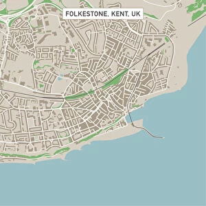
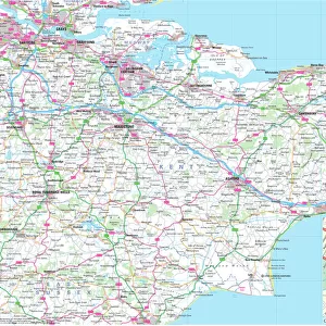
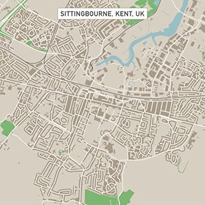
Ashford Kent UK City Street Map

![]()
Wall Art and Photo Gifts from Fine Art Storehouse
Ashford Kent UK City Street Map
Vector Illustration of a City Street Map of Ashford, Kent, UK. Included files are EPS (v10) and Hi-Res JPG.
Data courtesy from Ordnance Survey: VectorMap District
https:/ordnancesurvey.co.uk/business-and-government/products/vectormap-district.html
OS OpenData is free to use under the Open Government Licence (OGL).
Contains OS data eCrown copyright and database right 2017.
http:/nationalarchives.gov.uk/doc/open-government-licence/version/3/
Unleash your creativity and transform your space into a visual masterpiece!
Frank Ramspott
Media ID 15055217
© Frank Ramspott, all rights reserved
Aerial View Computer Graphic Directly Above Gray Green Kent Road Map Street Map Text Ashford Digitally Generated Image River Stour
FEATURES IN THESE COLLECTIONS
> Aerial Photography
> Related Images
> Arts
> Contemporary art
> Digital artwork
> Street art
> Arts
> Landscape paintings
> Waterfall and river artworks
> River artworks
> Arts
> Portraits
> Pop art gallery
> Street art portraits
> Arts
> Street art graffiti
> Digital art
> Digital paintings
> Arts
> Street art graffiti
> Digital art
> Vector illustrations
> Europe
> United Kingdom
> England
> Kent
> Ashford
> Europe
> United Kingdom
> England
> Kent
> Green Street Green
> Europe
> United Kingdom
> England
> Kent
> Kent Street
> Europe
> United Kingdom
> Maps
> Fine Art Storehouse
> Map
> Street Maps
EDITORS COMMENTS
This print showcases a meticulously detailed vector illustration of the charming city street map of Ashford, Kent, UK. Created by talented artist Frank Ramspott, this artwork is a perfect blend of cartography and design. The image features various elements such as buildings, streets, roads, and the serene River Stour flowing through the city. The use of vibrant colors like gray, green, blue, and white adds depth to the digitally generated image while highlighting different areas within Ashford. With no people in sight, this aerial view provides an uninterrupted perspective directly from above. What makes this artwork even more remarkable is its source data courtesy from Ordnance Survey: VectorMap District. This reliable information ensures accuracy and authenticity in depicting the city's layout. Displayed on high-resolution JPG format along with EPS (v10) files included for versatility in usage options; this print offers both aesthetic appeal and practicality. It serves as an excellent addition to any art collection or as a thoughtful gift for those who appreciate fine craftsmanship.
MADE IN THE USA
Safe Shipping with 30 Day Money Back Guarantee
FREE PERSONALISATION*
We are proud to offer a range of customisation features including Personalised Captions, Color Filters and Picture Zoom Tools
SECURE PAYMENTS
We happily accept a wide range of payment options so you can pay for the things you need in the way that is most convenient for you
* Options may vary by product and licensing agreement. Zoomed Pictures can be adjusted in the Cart.