Home > Aerial Photography > Related Images
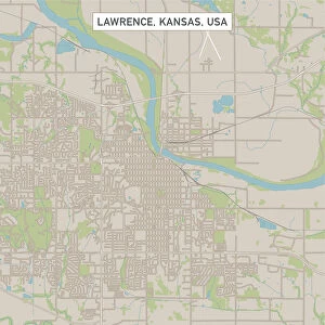
Topeka Kansas US City Street Map

![]()
Wall Art and Photo Gifts from Fine Art Storehouse
Topeka Kansas US City Street Map
Vector Illustration of a City Street Map of Topeka, Kansas, USA. Scale 1:60, 000.
All source data is in the public domain.
U.S. Geological Survey, US Topo
Used Layers:
USGS The National Map: National Hydrography Dataset (NHD)
USGS The National Map: National Transportation Dataset (NTD)
Unleash your creativity and transform your space into a visual masterpiece!
Frank Ramspott
Media ID 15215778
© Frank Ramspott, all rights reserved
Aerial View City Map Computer Graphic Directly Above Downtown District Gray Kansas Road Map Text Digitally Generated Image Green Color Topeka White Color
FEATURES IN THESE COLLECTIONS
> Aerial Photography
> Related Images
> Animals
> Insects
> Hemiptera
> Green Scale
> Arts
> Contemporary art
> Digital artwork
> Street art
> Arts
> Landscape paintings
> Waterfall and river artworks
> River artworks
> Arts
> Portraits
> Pop art gallery
> Street art portraits
> Arts
> Street art graffiti
> Digital art
> Digital paintings
> Arts
> Street art graffiti
> Digital art
> Vector illustrations
> Fine Art Storehouse
> Map
> Street Maps
> Fine Art Storehouse
> Map
> USA Maps
> Maps and Charts
> Geological Map
> Maps and Charts
> Related Images
> North America
> United States of America
> Kansas
> Kansas City
EDITORS COMMENTS
This print showcases a meticulously detailed vector illustration of the vibrant city street map of Topeka, Kansas, USA. With a scale of 1:60,000, every intricate detail is brought to life in this visually stunning artwork. The artist, Frank Ramspott, skillfully utilized various layers from trusted sources such as the U. S. Geological Survey and US Topo to create this masterpiece. The print captures the essence of Topeka's downtown district with its bustling streets and charming architecture. It also highlights the natural beauty surrounding the city, including a serene lake and meandering river that add an element of tranquility to the urban landscape. Rendered in shades of gray, blue, white, and green colors against a backdrop of textural elements, this digitally generated image offers a unique perspective on Topeka's physical geography. The aerial view from directly above provides viewers with an immersive experience as they explore every road and avenue intricately depicted on this map. Perfect for cartography enthusiasts or those with an appreciation for design and artistry alike, this print is sure to captivate any observer. Its absence of people allows one to focus solely on the architectural marvels and intricate details that make up Topeka's cityscape. A true testament to Frank Ramspott's talent as an artist and his dedication to creating visually striking pieces inspired by real-world locations.
MADE IN THE USA
Safe Shipping with 30 Day Money Back Guarantee
FREE PERSONALISATION*
We are proud to offer a range of customisation features including Personalised Captions, Color Filters and Picture Zoom Tools
SECURE PAYMENTS
We happily accept a wide range of payment options so you can pay for the things you need in the way that is most convenient for you
* Options may vary by product and licensing agreement. Zoomed Pictures can be adjusted in the Cart.