Home > Arts > Landscape paintings > Waterfall and river artworks > River artworks
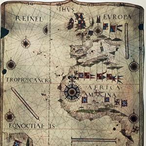
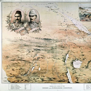
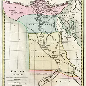
AFRICA: MAP. Birds eye view of the Sudan and surrounding countries

![]()
Wall Art and Photo Gifts from Granger
AFRICA: MAP. Birds eye view of the Sudan and surrounding countries
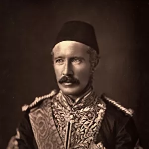
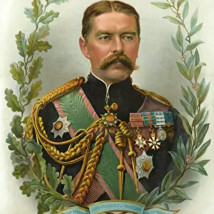
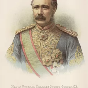
AFRICA: MAP. Birds eye view of the Sudan and surrounding countries. English lithograph map, 1884, of north, central, and east Africa, featuring the portraits of General Charles Gordon and Colonel Herbert Stewart, both of whom served at Khartoum
Granger holds millions of images spanning more than 25,000 years of world history, from before the Stone Age to the dawn of the Space Age
Media ID 6622485
1884 African British Empire Colonialism Colonist East Africa Gordon Herbert Khartoum Stuart Central Africa
FEATURES IN THESE COLLECTIONS
> Africa
> Related Images
> Africa
> Sudan
> Related Images
> Arts
> Landscape paintings
> Waterfall and river artworks
> River artworks
> Granger Art on Demand
> Maps
> Maps and Charts
> British Empire Maps
> Maps and Charts
> Related Images
EDITORS COMMENTS
This lithograph map from 1884 offers a mesmerizing birds-eye view of the Sudan and its neighboring countries in Africa. The intricate details and artistic craftsmanship transport us back to a time when exploration and colonialism were at their peak. The map showcases the vast expanse of north, central, and east Africa, highlighting key geographical features such as rivers and mountains. However, what truly sets this print apart are the portraits featured on it - those of General Charles Gordon and Colonel Herbert Stewart. Both men played significant roles in the historical events that unfolded in Khartoum. General Charles Gordon's portrait reminds us of his valiant service during his time at Khartoum, while Colonel Herbert Stewart's presence adds another layer to this narrative of British empire expansion. Their inclusion serves as a testament to their contributions within the context of colonialism. As we gaze upon this remarkable piece, we cannot help but be transported to an era where boundaries were being redrawn both physically and politically. This lithograph map is not just an artistic representation; it encapsulates a pivotal moment in history when European powers sought control over African territories. Granger Art on Demand has once again provided us with an extraordinary glimpse into our past through this thought-provoking print from their collection.
MADE IN THE USA
Safe Shipping with 30 Day Money Back Guarantee
FREE PERSONALISATION*
We are proud to offer a range of customisation features including Personalised Captions, Color Filters and Picture Zoom Tools
SECURE PAYMENTS
We happily accept a wide range of payment options so you can pay for the things you need in the way that is most convenient for you
* Options may vary by product and licensing agreement. Zoomed Pictures can be adjusted in the Cart.