Home > Battlefields of World War I
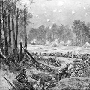
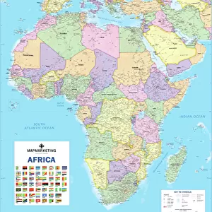
Northern France Illustrating the Western Campaign, 1914, (c1920)
")
![]()
Wall Art and Photo Gifts from Heritage Images
Northern France Illustrating the Western Campaign, 1914, (c1920)
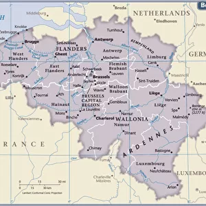
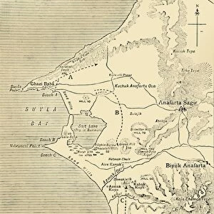
Northern France Illustrating the Western Campaign, 1914, (c1920). Map of northern France, Belgium and Luxembourg, at the start of the First World War. From " The Great World War - A History" Volume I, edited by Frank A Mumby. [The Gresham Publishing Company Ltd, London, c1920]
Heritage Images features heritage image collections
Media ID 19174204
© The Print Collector/Heritage Images
Aisne Bartholomew Bartholomew And Co Bartholomew Co Bartholomew John Son Champagne Ardenne Frank Arthur Frank Arthur Mumby Front Line Frontier Frontiers Frontline Gresham Publishing Co Ltd Gresham Publishing Company Jg Bartholomew John And Son John Bartholomew And Co John Bartholomew And Son John Bartholomew And Son Ltd John Bartholomew Co John Bartholomew Son John Bartholomew Son Ltd John Son Keystone Archives Laon Mumby Mumby Frank Arthur Paris Ile De France France Picardy Railway Line Railway Track Railway Tracks Reims Rheims Rheims Champagne Ardenne France Roads Soissons Soissons Aisne Picardy France The Great World War A History Theatre Of War Train Track Battlefield
FEATURES IN THESE COLLECTIONS
> Europe
> Belgium
> Related Images
> Europe
> France
> Canton
> Aisne
> Europe
> France
> Canton
> Ardennes
> Europe
> France
> Paris
> Maps
EDITORS COMMENTS
This print titled "Northern France Illustrating the Western Campaign, 1914" takes us back in time to the tumultuous era of the First World War. The map, originally featured in Frank A Mumby's historical masterpiece "The Great World War - A History" offers a vivid depiction of northern France, Belgium, and Luxembourg at the onset of this devastating conflict. As we gaze upon this meticulously crafted illustration by John Bartholomew & Son, we are transported to an era where borders were defined by frontiers and battle lines. The vibrant colors bring life to the intricate railway tracks and roads that crisscross through these war-torn lands. The significance of this image lies not only in its cartographic accuracy but also in its ability to evoke a sense of awe and curiosity about the events that unfolded during those dark times. It serves as a reminder of the countless lives lost and sacrifices made on these very grounds. From Paris to Reims, from Laon to Rheims, every location marked on this map holds stories waiting to be discovered. It is a testament to both human resilience and tragedy – capturing not just physical landscapes but also emotions etched into history. This print stands as a powerful symbol of remembrance for all those who fought bravely during one of humanity's most challenging chapters. Let it serve as a constant reminder that peace should never be taken for granted and that understanding our past is crucial for shaping our future.
MADE IN THE USA
Safe Shipping with 30 Day Money Back Guarantee
FREE PERSONALISATION*
We are proud to offer a range of customisation features including Personalised Captions, Color Filters and Picture Zoom Tools
SECURE PAYMENTS
We happily accept a wide range of payment options so you can pay for the things you need in the way that is most convenient for you
* Options may vary by product and licensing agreement. Zoomed Pictures can be adjusted in the Cart.