Home > Animals > Mammals > Muridae > Steppe Mouse
Caucasian oilfields by G. H. Davis

![]()
Wall Art and Photo Gifts from Mary Evans Picture Library
Caucasian oilfields by G. H. Davis
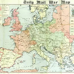
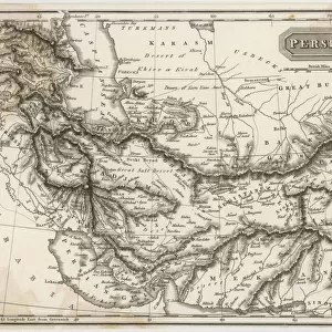
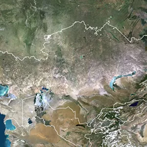
The Achilles Heel of the Soviets: the Caucasian oilfields. A pictorial map of the strategically vulnerable oilfields on either side of the Caucasus upon which Russia depends for the bulk of her supplies, and (inset) the small but remote Bashkir Field.
1940
Mary Evans Picture Library makes available wonderful images created for people to enjoy over the centuries
Media ID 14125243
© Illustrated London News Ltd/Mary Evans
Achilles Armenia Bashkir Caspian Caucasian Caucasus Davis Depending Fields Fuel Heel Iran Kazakhstan Lines Oilfields Pictorial Pipe Pipelines Railways Refineries Remote Soviet Soviets Steppes Strategic Strategically Supplies Supply Ussr Vulnerable Dependent
FEATURES IN THESE COLLECTIONS
> Animals
> Mammals
> Muridae
> Steppe Mouse
> Asia
> Armenia
> Related Images
> Asia
> Iran
> Lakes
> Caspian Sea
> Asia
> Iran
> Related Images
> Asia
> Kazakhstan
> Lakes
> Caspian Sea
> Asia
> Kazakhstan
> Maps
> Asia
> Kazakhstan
> Related Images
> Asia
> Turkey
> Related Images
The Achilles Heel of the Soviets - the Caucasian Oilfields
EDITORS COMMENTS
is a striking and evocative title given to this 1940 photographic map by G.H. Davis, published by the Illustrated London News Ltd. The image offers a vivid portrayal of the strategically vulnerable oilfields on either side of the Caucasus Mountains, which at the time were a critical source of fuel for the Soviet Union, supplying the bulk of its oil needs. The map highlights the importance of the region, with the inset focusing on the small but remote Bashkir Field, which was particularly significant due to its proximity to the Caspian Sea and the Black Sea. The map also illustrates the key production sites, refineries, pipelines, and railways that were essential for transporting the oil from the fields to the rest of the Soviet Union. The Caucasus region was a strategically important area during World War II, as control of its oilfields could potentially give an advantage to any invading force. The map underscores this point, with the inclusion of neighboring countries such as Turkey, Armenia, Iran, and Kazakhstan, which bordered the Soviet Union and could potentially impact the flow of oil. The map also serves as a reminder of the importance of oil in wartime, with the Soviet Union relying heavily on these fields to fuel its military machine. The vulnerability of these oilfields, which were spread out over a vast area and difficult to defend, made them a potential weak point for the Soviet Union during the conflict. Overall, this photographic map by G.H. Davis provides a valuable historical perspective on the strategic importance of the Caucasian oilfields during World War II and highlights the challenges faced by the Soviet Union in maintaining its oil supplies during a time of conflict.
MADE IN THE USA
Safe Shipping with 30 Day Money Back Guarantee
FREE PERSONALISATION*
We are proud to offer a range of customisation features including Personalised Captions, Color Filters and Picture Zoom Tools
SECURE PAYMENTS
We happily accept a wide range of payment options so you can pay for the things you need in the way that is most convenient for you
* Options may vary by product and licensing agreement. Zoomed Pictures can be adjusted in the Cart.