Home > Europe > United Kingdom > England > London > Politics > Frederick North
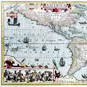
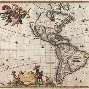
Map of the Americas, 1660

![]()
Wall Art and Photo Gifts from Science Photo Library
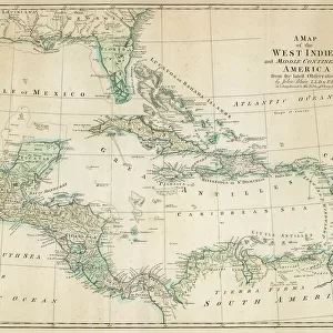
Map of the Americas, 1660
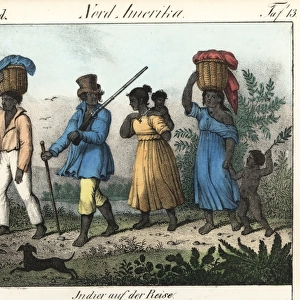
17th century map of the Americas. Published in Amsterdam in 1660, this map by the Dutch cartographer Frederick de Witt (1630-1706) shows the geography of the Americas, the New World being explored by Europeans. The exploration of South America was well advanced by this stage, but large swathes of North America had yet to be mapped. The artworks across top show various cities, from left to right: Cusco (Peru); Tenochtitlan (labelled Mexico, now Mexico City); Olinda (Brazil); Havana (Cuba); San Domingo (Hispaniola); and Cartagena (Colombia). The artworks at left and right show natives of Virginia (north-eastern North America), Chile and Brazil, and the Magellanic people of Patagonia
Science Photo Library features Science and Medical images including photos and illustrations
Media ID 1699849
© LIBRARY OF CONGRESS, GEOGRAPHY AND MAP DIVISION/SCIENCE PHOTO LIBRARY
1600s 1660 17th Century Age Of Discovery Brazil Caribbean Cartography Chile Cities City Colonies Colony Continent Continental Continents Dutch Empire Exploration French Hispaniola Medieval Mexico City Middle Ages Native Natives New World North American South America South American Spanish Virginia Cartagena Cusco Havana Olinda San Domingo Tenochtitlan
FEATURES IN THESE COLLECTIONS
> Arts
> Art Movements
> Medieval Art
> Europe
> Related Images
> Europe
> Spain
> Related Images
> Europe
> United Kingdom
> England
> London
> Politics
> Frederick North
> Maps and Charts
> Early Maps
> Science Photo Library
> History
EDITORS COMMENTS
This print takes us back to the 17th century, immersing us in the age of exploration and colonialism. Published in Amsterdam in 1660 by Dutch cartographer Frederick de Witt, this map of the Americas offers a glimpse into how Europeans perceived and navigated the New World. While South America had been extensively explored at this point, large portions of North America remained uncharted. The top section of the map showcases stunning artworks depicting various cities that were significant during that time. From left to right, we see Cusco (Peru), Tenochtitlan (now Mexico City), Olinda (Brazil), Havana (Cuba), San Domingo (Hispaniola), and Cartagena (Colombia). These vibrant illustrations provide a visual representation of the diverse cultures and settlements across these regions. To further enrich our understanding, portraits on both sides depict natives from different parts of the Americas: Virginia in northeastern North America, Chile, Brazil, and even the Magellanic people from Patagonia. These images offer glimpses into their lives during this period of history. As we explore this remarkable map print, it serves as a reminder of an era marked by discovery and conquest. It allows us to appreciate how far our knowledge has evolved since then while also acknowledging its historical significance. This piece is not just a mere depiction; it's an invitation to delve into centuries past when continents were still being charted and new worlds awaited exploration.
MADE IN THE USA
Safe Shipping with 30 Day Money Back Guarantee
FREE PERSONALISATION*
We are proud to offer a range of customisation features including Personalised Captions, Color Filters and Picture Zoom Tools
SECURE PAYMENTS
We happily accept a wide range of payment options so you can pay for the things you need in the way that is most convenient for you
* Options may vary by product and licensing agreement. Zoomed Pictures can be adjusted in the Cart.