Home > Europe > Related Images
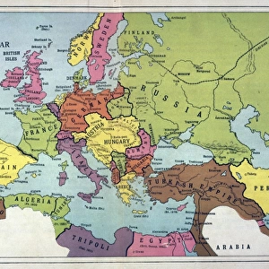
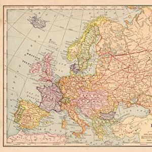
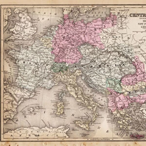
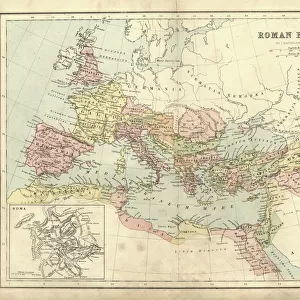
Central Europe map 1892

![]()
Wall Art and Photo Gifts from Fine Art Storehouse
Central Europe map 1892
Frye Grammar School Geography - 1892
Unleash your creativity and transform your space into a visual masterpiece!
THEPALMER
Media ID 14756020
© This content is subject to copyright
FEATURES IN THESE COLLECTIONS
> Europe
> Related Images
> Fine Art Storehouse
> Map
> Historical Maps
> Maps and Charts
> Related Images
EDITORS COMMENTS
This print showcases a historical gem, the "Central Europe map 1892 (Frye Grammar School Geography - 1892)" captured by THEPALMER and available at Fine Art Storehouse. Transporting us back to the late 19th century, this meticulously detailed map offers a fascinating glimpse into the geographical landscape of Central Europe during that era. The intricate cartography presents an array of countries, cities, rivers, and mountain ranges that defined this region's rich history. Each line and contour on this vintage map tells a story of exploration, conquests, and cultural exchange. It serves as a testament to the craftsmanship involved in creating such comprehensive representations before modern technology took over. The sepia tones add an air of nostalgia to the image while enhancing its antique charm. This piece is not just an artistic delight but also holds immense educational value for geography enthusiasts or anyone curious about how borders have evolved over time. Whether displayed in a classroom or adorning your home office wall, this print invites you to embark on a visual journey through time. Immerse yourself in the past as you trace trade routes or imagine what life was like for those who inhabited these lands more than a century ago. "The Central Europe map 1892" is more than just decoration; it is an invitation to explore history from an entirely new perspective – one that allows us to appreciate both our present world and how far we've come since then.
MADE IN THE USA
Safe Shipping with 30 Day Money Back Guarantee
FREE PERSONALISATION*
We are proud to offer a range of customisation features including Personalised Captions, Color Filters and Picture Zoom Tools
SECURE PAYMENTS
We happily accept a wide range of payment options so you can pay for the things you need in the way that is most convenient for you
* Options may vary by product and licensing agreement. Zoomed Pictures can be adjusted in the Cart.