Home > Maps and Charts > British Empire Maps
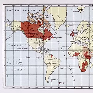
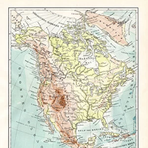
British Empire map, 19th century engraving

![]()
Wall Art and Photo Gifts from Liszt Collection
British Empire map, 19th century engraving
Liszt Collection of nineteenth-century engravings and images to browse and enjoy
Media ID 12953162
© Quint Lox Limited
EDITORS COMMENTS
This print showcases a remarkable piece of history - a British Empire map from the 19th century, meticulously engraved with intricate details. The Liszt Collection has beautifully preserved this artifact, allowing us to delve into the grandeur and vastness of one of the most influential empires in human history. As we gaze upon this map, we are transported back to an era when Britannia ruled the waves and her empire spanned continents. Every inch of this engraving tells a story; it reveals the extent of Britain's dominion across oceans and lands far beyond its shores. From India to Africa, Australia to Canada, each territory is intricately outlined with precision and care. The artistry involved in creating such a masterpiece is awe-inspiring. The delicate lines etched onto paper capture not only geographical boundaries but also evoke a sense of power and ambition that defined an entire era. This map serves as a testament to Britain's imperial might during the 19th century. Beyond its historical significance, this print offers us an opportunity for reflection. It prompts us to ponder on both the positive contributions made by the British Empire as well as its darker aspects - colonization, exploitation, and cultural assimilation. In preserving this engraving from their collection without commercial intentions or affiliations with any company, Liszt Collection invites us to appreciate our shared past while encouraging critical examination of colonial legacies that continue to shape our world today.
MADE IN THE USA
Safe Shipping with 30 Day Money Back Guarantee
FREE PERSONALISATION*
We are proud to offer a range of customisation features including Personalised Captions, Color Filters and Picture Zoom Tools
SECURE PAYMENTS
We happily accept a wide range of payment options so you can pay for the things you need in the way that is most convenient for you
* Options may vary by product and licensing agreement. Zoomed Pictures can be adjusted in the Cart.