Home > Europe > Denmark > Maps
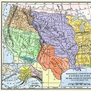
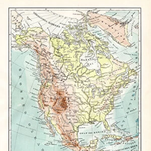
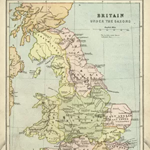
Map from 1898 showing the territorial growth of the United States of America

![]()
Wall Art and Photo Gifts from Universal Images Group (UIG)
Map from 1898 showing the territorial growth of the United States of America
Map from 1898 showing the territorial growth of the United States of America. From The History of Our Country, published 1900
Universal Images Group (UIG) manages distribution for many leading specialist agencies worldwide
Media ID 20165289
© Ken Welsh / Design Pics
1898 Alaska America American Century Country Danish Denmark Expansion Growth Kingdom Louisiana Mexican Mexico Nineteenth Original Russian Spain Spanish State States Territorial Territory Texas Thirteen Treaty United Annexation Annexes Cession Conquests Purchase Purchases
FEATURES IN THESE COLLECTIONS
> Europe
> Denmark
> Related Images
> Europe
> Russia
> Related Images
> Europe
> United Kingdom
> England
> Maps
> Maps and Charts
> Early Maps
> Universal Images Group (UIG)
> History
> Historical Maps
> Universal Images Group (UIG)
> Universal Images Group
> Universal History Archive
> History
EDITORS COMMENTS
This print showcases a remarkable map from 1898, unveiling the extraordinary territorial growth of the United States of America. A true testament to the nation's expansionist spirit, this historical artifact traces the country's journey towards becoming a vast and diverse landmass. From its humble beginnings as thirteen original states, this map vividly illustrates how America acquired new territories through conquests, purchases, and annexations. The cartographic masterpiece highlights significant milestones in American history such as the Louisiana Purchase, which doubled the size of the nation overnight. It also includes Texas' annexation and Alaska's acquisition from Russia – both pivotal moments that shaped America's geography. Through treaties with various European powers like Spain and France, Britain and Denmark, these lands were added to an ever-growing United States. The Mexican Cession following a war with Mexico further expanded America's borders southwards. As we gaze upon this intricate illustration from over a century ago, it serves as a powerful reminder of our nation's relentless pursuit for progress and manifest destiny. This map not only captures geographical changes but also symbolizes the resilience and ambition that define us as Americans. With each territory gained on this mesmerizing map comes stories untold – tales of exploration, settlement, conflict, cultural exchange - all contributing to shaping what we know today as one united country: The United States of America.
MADE IN THE USA
Safe Shipping with 30 Day Money Back Guarantee
FREE PERSONALISATION*
We are proud to offer a range of customisation features including Personalised Captions, Color Filters and Picture Zoom Tools
SECURE PAYMENTS
We happily accept a wide range of payment options so you can pay for the things you need in the way that is most convenient for you
* Options may vary by product and licensing agreement. Zoomed Pictures can be adjusted in the Cart.