Home > Europe > United Kingdom > Scotland > Maps
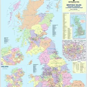
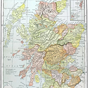
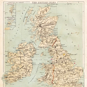
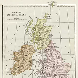
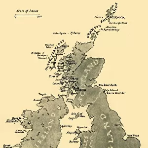
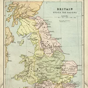
MAP: BRITISH ISLES, c1890. Map of the British Isles, c1890, by a German cartographer

![]()
Wall Art and Photo Gifts from Granger
MAP: BRITISH ISLES, c1890. Map of the British Isles, c1890, by a German cartographer
MAP: BRITISH ISLES, c1890. Map of the British Isles, c1890, by a German cartographer, published in the United States
Granger holds millions of images spanning more than 25,000 years of world history, from before the Stone Age to the dawn of the Space Age
Media ID 6616275
Ireland Irish Scot Land Scottish Victorian Wales Welsh
FEATURES IN THESE COLLECTIONS
> Arts
> Landscape paintings
> Waterfall and river artworks
> River artworks
> Europe
> France
> Canton
> Landes
> Europe
> Germany
> Related Images
> Europe
> Republic of Ireland
> Maps
> Europe
> United Kingdom
> England
> Maps
> Europe
> United Kingdom
> England
> Rivers
> Europe
> United Kingdom
> Scotland
> Maps
> Europe
> United Kingdom
> Scotland
> Posters
> Granger Art on Demand
> Maps
EDITORS COMMENTS
This print showcases a vintage map of the British Isles, dating back to around 1890. Created by a skilled German cartographer, this intricate piece was later published in the United States. The map provides an intriguing glimpse into the geographical landscape and political divisions of that era. With its rich details and elegant design, this map transports us to a time when Scotland, Ireland, Wales, and England were united under one crown. Each region is clearly demarcated with their respective names proudly displayed. The Scottish Highlands are depicted with their rugged beauty while Irish rivers gracefully wind through the countryside. The Victorian influence is evident in the ornate typography and decorative elements adorning the borders of this historical artifact. It serves as a testament to both artistic craftsmanship and scientific accuracy prevalent during that period. Whether you have ancestral ties to these lands or simply appreciate cartographic artistry, this print offers an opportunity for reflection on how boundaries have evolved over time. It invites us to explore our own connections to these regions while appreciating the skillful workmanship of a talented German cartographer from more than a century ago. Displayed prominently on your wall or carefully preserved within your collection, this Granger Collection print will undoubtedly spark conversations about history, geography, and cultural heritage for years to come.
MADE IN THE USA
Safe Shipping with 30 Day Money Back Guarantee
FREE PERSONALISATION*
We are proud to offer a range of customisation features including Personalised Captions, Color Filters and Picture Zoom Tools
SECURE PAYMENTS
We happily accept a wide range of payment options so you can pay for the things you need in the way that is most convenient for you
* Options may vary by product and licensing agreement. Zoomed Pictures can be adjusted in the Cart.