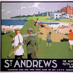
Home > Europe > United Kingdom > Scotland > Fife > St Andrews
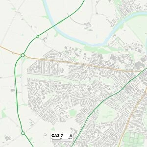
Carlisle CA5 6 Map

![]()
Wall Art and Photo Gifts from Map Marketing
Carlisle CA5 6 Map
Postcode Sector Map of Carlisle CA5 6
Media ID 19966918
Brook Close Carlisle Chapel Field Church Lane Grange Park Road Greenwood Close Hillcroft Holme Lane Lawrence Lane Meadow Croft Milton Lane Moor Close Moorend Oaks Lane Orchard Close School Road Southfield St Andrews Close Station Road The Paddocks The Park Wallace Lane West Park Beaumont Ludgate Hill Moorhouse Westhaven Woodville
FEATURES IN THESE COLLECTIONS
> Europe
> United Kingdom
> Scotland
> Fife
> St Andrews
> Map Marketing
> Postcode Sector Maps
> CA - Carlisle
> Maps and Charts
> Related Images
MADE IN THE USA
Safe Shipping with 30 Day Money Back Guarantee
FREE PERSONALISATION*
We are proud to offer a range of customisation features including Personalised Captions, Color Filters and Picture Zoom Tools
SECURE PAYMENTS
We happily accept a wide range of payment options so you can pay for the things you need in the way that is most convenient for you
* Options may vary by product and licensing agreement. Zoomed Pictures can be adjusted in the Cart.