Home > Arts > Artists > J > James Jefferys
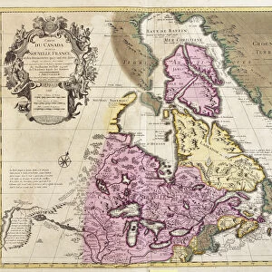
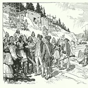
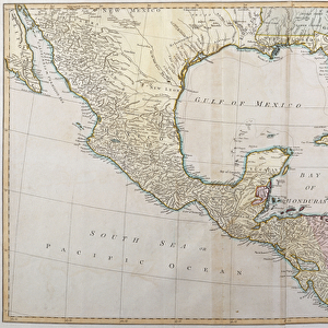
A Correct Plan of the environs of Quebec and of the battle fought on 13th September

![]()
Wall Art and Photo Gifts from Fine Art Finder
A Correct Plan of the environs of Quebec and of the battle fought on 13th September
3058239 A Correct Plan of the environs of Quebec and of the battle fought on 13th September, 1759 (engraving) by Jefferys, Thomas (c.1719-71); Private Collection; (add.info.: Detailed topographical map of Wolfes blockade of Quebec against the French under Montcalm. ); English, out of copyright
Media ID 23428478
© Bridgeman Images
Battle Of Quebec Cartographic Colonies French And Indian War General Wolfe James Wolfe New France Plains Of Abraham Quebec Settlement Seven Years War St Lawrence Strategic Strategy Tactical Tactics America Continent Canadians
FEATURES IN THESE COLLECTIONS
> Animals
> Mammals
> Muridae
> Plains Mouse
> Arts
> Artists
> J
> James Jefferys
> Arts
> Artists
> J
> Thomas Jefferys
> Arts
> Artists
> L
> Thomas Lawrence
> Arts
> Artists
> N
> Thomas North
> Arts
> Photorealistic artworks
> Detailed art pieces
> Masterful detailing in art
> Fine Art Finder
> Artists
> English School
> Fine Art Finder
> Artists
> Thomas Jefferys
> Historic
> Battles
> Related Images
EDITORS COMMENTS
This print titled "A Correct Plan of the environs of Quebec and of the battle fought on 13th September, 1759" takes us back to a significant moment in history. Created by Thomas Jefferys, this detailed topographical map showcases General Wolfe's strategic blockade of Quebec against the French under Montcalm during the French and Indian War. The image captures the essence of warfare and strategy as it depicts Vice Admiral Saunders leading his navy along the St. Lawrence River while Major General Wolfe commands his army on land. The settlement of Quebec stands prominently in the background, symbolizing both British colonial ambitions and French resistance. Brigadier Generals Townshend and Monckton can be seen coordinating tactical movements with their troops on the Plains of Abraham, where one decisive battle would determine control over Canada. This plan not only highlights key military positions but also emphasizes how cartography played a vital role in understanding terrain for successful campaigns. As we delve into this historical artifact, we are reminded of how this victory shaped North America's destiny. It marked a turning point in British dominance over New France and set the stage for future conflicts that would shape our continent's history. This print serves as a testament to James Wolfe's leadership, showcasing his meticulous planning and determination to secure victory for Britain in its quest for empire-building. As we admire this piece from Bridgeman Images' private collection, let us reflect upon the bravery displayed by all those involved in this pivotal moment within our
MADE IN THE USA
Safe Shipping with 30 Day Money Back Guarantee
FREE PERSONALISATION*
We are proud to offer a range of customisation features including Personalised Captions, Color Filters and Picture Zoom Tools
FREE COLORIZATION SERVICE
You can choose advanced AI Colorization for this picture at no extra charge!
SECURE PAYMENTS
We happily accept a wide range of payment options so you can pay for the things you need in the way that is most convenient for you
* Options may vary by product and licensing agreement. Zoomed Pictures can be adjusted in the Cart.