Home > Africa > Related Images
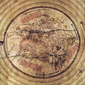
Map of Turkey, Arabia and Persia, after Guillaume de L Isle, revised by John Senex

![]()
Wall Art and Photo Gifts from Fine Art Finder
Map of Turkey, Arabia and Persia, after Guillaume de L Isle, revised by John Senex
KW359928 Map of Turkey, Arabia and Persia, after Guillaume de L Isle, revised by John Senex, from the New General Atlas of 1721 by D. Browne, T. Taylor, J. Darby, J, Senex, W. Taylor and four others in London (colour litho) by English School, (18th century); Private Collection; Ken Welsh; English, out of copyright
Media ID 12865431
© www.bridgemanimages.com
Cartouche Grid Iran Mapping Territory Gulf States
FEATURES IN THESE COLLECTIONS
> Africa
> Related Images
> Asia
> Related Images
> Asia
> Turkey
> Related Images
> Europe
> United Kingdom
> England
> London
> Related Images
EDITORS COMMENTS
This print showcases a historical treasure, the "Map of Turkey, Arabia and Persia" meticulously crafted by Guillaume de L Isle and later revised by John Senex. Created in 1721 as part of the New General Atlas, this map offers a fascinating glimpse into the cartographic mastery of its time. The intricate details on this map highlight the vast territories of Turkey, Arabia, and Persia, capturing their geographical features with remarkable accuracy. From the sprawling deserts to the majestic mountain ranges, every contour is carefully depicted to provide an authentic representation of these regions. The vibrant colors used in this lithograph bring life to the ancient lands it portrays. The warm hues beautifully accentuate each country's distinct borders while seamlessly blending them together as one cohesive unit. A stunning cartouche adorns one corner of the map, adding an artistic touch that enhances its overall aesthetic appeal. As we delve deeper into this masterpiece, our eyes are drawn towards Africa and Asia surrounding these Middle Eastern territories. This inclusion serves as a reminder that these nations were not isolated entities but rather integral parts of larger continental landscapes. Preserved within a private collection today, this print allows us to appreciate both the artistry and historical significance embedded within its lines. It stands as a testament to human curiosity and exploration—a tangible link between past and present—inviting us to explore distant lands through cartography's lens.
MADE IN THE USA
Safe Shipping with 30 Day Money Back Guarantee
FREE PERSONALISATION*
We are proud to offer a range of customisation features including Personalised Captions, Color Filters and Picture Zoom Tools
SECURE PAYMENTS
We happily accept a wide range of payment options so you can pay for the things you need in the way that is most convenient for you
* Options may vary by product and licensing agreement. Zoomed Pictures can be adjusted in the Basket.