Home > Arts > Street art graffiti > Digital art > Vector illustrations
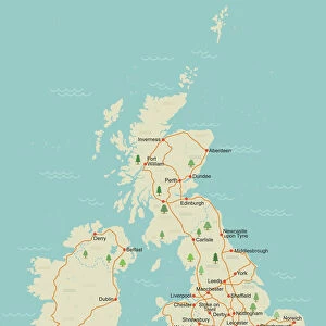
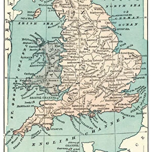
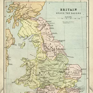
England Vector Map Colorful Administrative Divisions

![]()
Wall Art and Photo Gifts from Fine Art Storehouse
England Vector Map Colorful Administrative Divisions
Vector map of England with Administrative Divisions. The colors in the.eps-file are ready for print (CMYK). Included files are EPS (v10) and Hi-Res JPG (4922 x 4922 px). Made with Natural Earth. The source data is in the public domain. URL of source data: http:/naturalearthdata
Unleash your creativity and transform your space into a visual masterpiece!
Frank Ramspott
Media ID 14549509
© Frank Ramspott, all rights reserved
Border Circle Clip Art Colorful Computer Graphic Country Geographic Area Geography Latitude Longitude Square Vector Digitally Generated Image
FEATURES IN THESE COLLECTIONS
> Arts
> Street art graffiti
> Digital art
> Digital paintings
> Arts
> Street art graffiti
> Digital art
> Vector illustrations
> Europe
> United Kingdom
> England
> Maps
> Europe
> United Kingdom
> England
> Paintings
> Europe
> United Kingdom
> England
> Posters
> Europe
> United Kingdom
> Maps
> Europe
> United Kingdom
> Paintings
> Maps and Charts
> Related Images
EDITORS COMMENTS
This vibrant and detailed print showcases the England Vector Map with its colorful Administrative Divisions. Perfect for cartography enthusiasts, this digitally generated image is a stunning piece of art that captures the essence of England's geographic beauty. The EPS-file format ensures high-quality printing with CMYK colors, making it ideal for any design project or decorative purposes. Created using Natural Earth as the primary data source, this vector map accurately represents England's administrative divisions while adhering to public domain guidelines. With a resolution of 4922 x 4922 pixels, the included Hi-Res JPG file guarantees sharpness and clarity in every detail. The composition features an eye-catching square shape adorned with intricate borders that delineate each division. From bustling cities to serene countryside landscapes, this illustration beautifully encapsulates England's diverse regions and travel destinations. With no people present in the image, viewers can focus solely on appreciating the map's artistic qualities and geographical accuracy. Its computer-generated graphics lend a modern touch to traditional cartography techniques, resulting in a visually striking representation of England's country geographic area. Whether you're an avid traveler or simply admire exceptional design work, this colorful map print by Frank Ramspott is sure to captivate your imagination and add a touch of sophistication to any space.
MADE IN THE USA
Safe Shipping with 30 Day Money Back Guarantee
FREE PERSONALISATION*
We are proud to offer a range of customisation features including Personalised Captions, Color Filters and Picture Zoom Tools
SECURE PAYMENTS
We happily accept a wide range of payment options so you can pay for the things you need in the way that is most convenient for you
* Options may vary by product and licensing agreement. Zoomed Pictures can be adjusted in the Cart.