Home > Europe > France > Canton > Charente
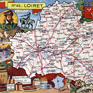
Map of the French Department of Charente - No. 16

![]()
Wall Art and Photo Gifts from Mary Evans Picture Library
Map of the French Department of Charente - No. 16
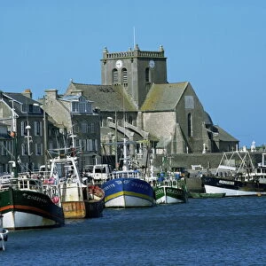
Map of the French Department of Charente - No.16, featuring inset illustrations of Paper production industry, La Rochefoucauld, produce and manufactured goods from Angouleme and an inset portrait of King Francis I of France (1494-1547) from the Angouleme branch of the House of Valois.
circa 1910s
Mary Evans Picture Library makes available wonderful images created for people to enjoy over the centuries
Media ID 14363922
© The Roseries Collection / Mary Evans Picture Library
Angouleme Cannon Chart Chateau Cognac Department Foodstuffs Francis Goods Manufactured Pate Plan Produce Rochefoucauld Valois Charente Safran
FEATURES IN THESE COLLECTIONS
> Animals
> Mammals
> Muridae
> House Mouse
> Arts
> Street art graffiti
> Portraits
> Fine art
> Europe
> France
> Canton
> Charente
> Maps and Charts
> Related Images
EDITORS COMMENTS
This map print, hailing from the early 1910s, showcases the French Department of Charente - No. 16. The intricately detailed chart highlights the various geographical features, towns, and villages that make up this historic region in southwestern France. Of particular note are the inset illustrations that adorn the map. The first, situated in the lower right corner, depicts the Paper Production Industry in La Rochefoucauld. This thriving industry was a significant contributor to the region's economy during this time, with La Rochefoucauld being renowned for its high-quality paper production. The second inset, located in the upper left corner, showcases the produce and manufactured goods from Angouleme. The region was famous for its diverse agricultural output, including fruits, vegetables, and grains. Angouleme was also known for its manufacturing sector, with industries such as textiles, metalworking, and food processing playing a prominent role. An exquisite portrait of King Francis I of France (1494-1547) from the Angouleme branch of the House of Valois graces the center of the map. King Francis I was a significant figure in French history, known for his patronage of the arts and his military campaigns. The House of Valois was a powerful and influential family during this period, with the Angouleme branch playing an essential role in the region's governance. The map also features various other points of interest, such as the imposing Chateau de la Rochefoucauld, the stunning Angouleme Cathedral, and the famous Cognac region. Additionally, the map includes illustrations of local produce and goods, such as cannon, pate, safran, and cathedral. This beautiful map print offers a fascinating glimpse into the rich history and culture of the French Department of Charente during the early 1900s.
MADE IN THE USA
Safe Shipping with 30 Day Money Back Guarantee
FREE PERSONALISATION*
We are proud to offer a range of customisation features including Personalised Captions, Color Filters and Picture Zoom Tools
SECURE PAYMENTS
We happily accept a wide range of payment options so you can pay for the things you need in the way that is most convenient for you
* Options may vary by product and licensing agreement. Zoomed Pictures can be adjusted in the Cart.