Home > Europe > United Kingdom > England > London > Sights > St Pauls Cathedral
Map of St Pauls and area

![]()
Wall Art and Photo Gifts from Mary Evans Picture Library
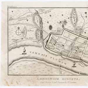
Map of St Pauls and area
Map of St Pauls and area in 1563 Date: 1563
Mary Evans Picture Library makes available wonderful images created for people to enjoy over the centuries
Media ID 20140429
© Bubblepunk
FEATURES IN THESE COLLECTIONS
> Europe
> United Kingdom
> England
> London
> Related Images
> Europe
> United Kingdom
> England
> London
> Sights
> St Pauls Cathedral
> Maps and Charts
> Related Images
> Mary Evans Prints Online
> London
> Mary Evans Prints Online
> New Images July 2020
EDITORS COMMENTS
This map print, dated 1563, offers a fascinating glimpse into the topography of St. Paul's Area in London during the Renaissance period. The map, which is not to be confused with modern-day map printing companies, provides a detailed and intricate representation of the city's geography, with St. Paul's Cathedral taking center stage. Located in the heart of London, St. Paul's Cathedral was a significant religious and architectural landmark even in the 16th century. The cathedral, which was rebuilt after the Great Fire of London in 1666, is depicted here as a grand edifice with its distinctive dome and surrounding buildings. The map also reveals the layout of the streets and waterways surrounding St. Paul's, including the River Thames, which played a crucial role in the city's economic and transportation activities. The map's intricate details provide insights into the various guilds, churches, and other institutions that were integral to the social fabric of London during this era. The map's antique charm and historical significance make it an essential addition to any collection of maps or London history. Its intricate details and rich history transport us back in time, allowing us to explore the city's past and appreciate the evolution of cartography over the centuries.
MADE IN THE USA
Safe Shipping with 30 Day Money Back Guarantee
FREE PERSONALISATION*
We are proud to offer a range of customisation features including Personalised Captions, Color Filters and Picture Zoom Tools
SECURE PAYMENTS
We happily accept a wide range of payment options so you can pay for the things you need in the way that is most convenient for you
* Options may vary by product and licensing agreement. Zoomed Pictures can be adjusted in the Cart.