Home > Europe > United Kingdom > England > Maps
Blockade of Boston

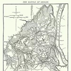
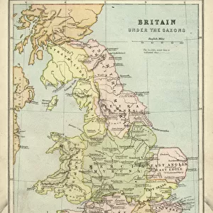
![]()
Wall Art and Photo Gifts from Fine Art Storehouse
Blockade of Boston
Vintage engraving from 1861 showing the Plan of the Blockade of Boston during the American Revolutionary War
Unleash your creativity and transform your space into a visual masterpiece!
duncan1890
Media ID 32086677
© duncan1890
18th Century Style American Culture American Revolution Armed Forces Battle Boston British Military Chart Conflict Document Eastern Usa Equipment Exclusion Geographical Locations Harbor Historic World Event Historical War Event Human Settlement Image Created 18th Century Information Equipment Man Made Massachusetts Military Military Invasion Navigational Equipment Navy New England North America Objects Equipment Past Plan Revolution Royal Navy Siege The Americas Travel Locations Obsolete
FEATURES IN THESE COLLECTIONS
> Europe
> United Kingdom
> England
> Maps
> Europe
> United Kingdom
> England
> Posters
> Fine Art Storehouse
> History
> Battles & Wars
> Historcal Battle Maps and Plans
> Fine Art Storehouse
> Map
> Historical Maps
> Historic
> Battles
> Related Images
> Historic
> World War I and II
> Historical events
> Historic
> World War I and II
> Military equipment
> Maps and Charts
> Early Maps
> Maps and Charts
> Related Images
> Maps and Charts
> World
> North America
> United States of America
> Maps
EDITORS COMMENTS
This vintage engraving from 1861 captures the intricate Plan of the Blockade of Boston during the American Revolutionary War. The detailed image, created in an 18th-century style, showcases the strategic cartography employed by the British military to control this crucial harbor city in Eastern USA. The black and white woodcut print transports us back to a historic world event, where conflict and revolution shaped American culture. With its obsolete depiction of armed forces and old-fashioned navigational equipment, it serves as a testament to past battles fought on these very shores. As we study this engraved image, we can imagine the tension that filled Boston's harbor during this military invasion. The map reveals how British forces meticulously planned their blockade strategy while excluding access for American ships. This antique document not only provides valuable historical information but also highlights human settlement patterns in Massachusetts and New England during that era. It reminds us of the importance of geographical locations in shaping our history. Duncan1890's print offers a glimpse into a pivotal moment when America fought for independence against colonial rule. It is both a visual representation of a significant battle and an object that connects us to our past—a tangible piece of history preserved through time.
MADE IN THE USA
Safe Shipping with 30 Day Money Back Guarantee
FREE PERSONALISATION*
We are proud to offer a range of customisation features including Personalised Captions, Color Filters and Picture Zoom Tools
SECURE PAYMENTS
We happily accept a wide range of payment options so you can pay for the things you need in the way that is most convenient for you
* Options may vary by product and licensing agreement. Zoomed Pictures can be adjusted in the Cart.