Home > Arts > Landscape paintings > Landscape art > Landscape paintings
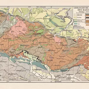
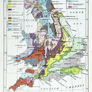
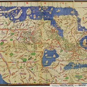
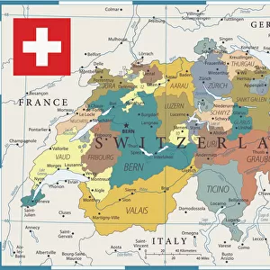
Geological map of southern Germany, Bohemia, Switzerland and Austria, published 1897

![]()
Wall Art and Photo Gifts from Fine Art Storehouse
Geological map of southern Germany, Bohemia, Switzerland and Austria, published 1897
Geological map of southern and central Germany, Bohemia, Switzerland and Austria. Lithograph, published in 1897
Unleash your creativity and transform your space into a visual masterpiece!
Media ID 14756156
© This content is subject to copyright
Austria Bohemia Devon European Alps Geology Igneous Igneous Rock Slate Soil Switzerland Volcanic Carbon Geological Map Jura Minerals Multi Colored Quaternary Silurian Tertiary
FEATURES IN THESE COLLECTIONS
> Arts
> Landscape paintings
> Landscape art
> Landscape paintings
> Europe
> Austria
> Related Images
> Europe
> Germany
> Related Images
> Europe
> Related Images
> Europe
> Switzerland
> Maps
> Europe
> Switzerland
> Posters
> Fine Art Storehouse
> Map
> Historical Maps
EDITORS COMMENTS
This lithograph, published in 1897, showcases a detailed geological map of southern Germany, Bohemia, Switzerland, and Austria. A true testament to the scientific advancements of its time, this print provides a glimpse into the rich history and diverse landscapes of these European regions. The intricate details on this map highlight various geological features that shaped the land over millions of years. From the towering peaks of the European Alps to the sprawling plains dotted with minerals and precious resources, every inch tells a story of Earth's evolution. Layers upon layers are unveiled as we explore this artwork - from quaternary deposits to ancient carbon formations; from Devonian rock formations to igneous outcrops; from slate quarries to Silurian sediments. The map also reveals significant periods such as Jura, Tertiary, Trias - each contributing unique characteristics to these lands. Vibrant colors bring life to this lithograph while providing visual cues about soil composition and volcanic activity across the region. Its horizontal layout allows for easy navigation through an array of information meticulously engraved onto its surface. As we gaze at this remarkable piece, it serves not only as a historical record but also as a reminder that beneath our feet lies an awe-inspiring tapestry woven by nature itself. Whether you're fascinated by geology or simply appreciate fine artistry capturing our planet's wonders – let this exquisite print transport you back in time and ignite your curiosity about Earth's magnificent past.
MADE IN THE USA
Safe Shipping with 30 Day Money Back Guarantee
FREE PERSONALISATION*
We are proud to offer a range of customisation features including Personalised Captions, Color Filters and Picture Zoom Tools
SECURE PAYMENTS
We happily accept a wide range of payment options so you can pay for the things you need in the way that is most convenient for you
* Options may vary by product and licensing agreement. Zoomed Pictures can be adjusted in the Cart.