Home > Aerial Photography > Related Images
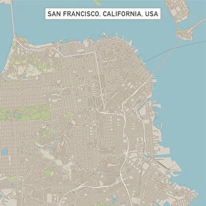
Ontario California US City Street Map

![]()
Wall Art and Photo Gifts from Fine Art Storehouse
Ontario California US City Street Map
Vector Illustration of a City Street Map of Ontario, California, USA. Scale 1:60, 000.
All source data is in the public domain.
U.S. Geological Survey, US Topo
Used Layers:
USGS The National Map: National Hydrography Dataset (NHD)
USGS The National Map: National Transportation Dataset (NTD)
Unleash your creativity and transform your space into a visual masterpiece!
Frank Ramspott
Media ID 15055117
© Frank Ramspott, all rights reserved
Aerial View California City Map Computer Graphic Directly Above Downtown District Gray Ontario Road Map Text Digitally Generated Image Green Color White Color
FEATURES IN THESE COLLECTIONS
> Aerial Photography
> Related Images
> Animals
> Insects
> Hemiptera
> Green Scale
> Animals
> Mammals
> Cricetidae
> California Mouse
> Arts
> Contemporary art
> Digital artwork
> Street art
> Arts
> Landscape paintings
> Waterfall and river artworks
> River artworks
> Arts
> Portraits
> Pop art gallery
> Street art portraits
> Arts
> Street art graffiti
> Digital art
> Digital paintings
> Arts
> Street art graffiti
> Digital art
> Vector illustrations
> Fine Art Storehouse
> Map
> Street Maps
> Fine Art Storehouse
> Map
> USA Maps
> Maps and Charts
> Geological Map
> Maps and Charts
> Related Images
EDITORS COMMENTS
This print showcases a meticulously detailed vector illustration of the vibrant city street map of Ontario, California, USA. With a scale of 1:60,000, every intricate feature is beautifully depicted in this artwork. The source data used for creating this masterpiece is all from the public domain and includes USGS The National Map: National Hydrography Dataset (NHD) and USGS The National Map: National Transportation Dataset (NTD). The image captures the essence of Ontario's downtown district with its bustling streets, meandering river, and serene lake. From roads to buildings and everything in between, this city map provides an accurate representation of the area's cartography. Digitally generated with impeccable precision and attention to detail, it offers a visually stunning aerial view directly above Ontario. In terms of color palette, shades of gray are elegantly combined with touches of green and blue against a clean white background. This creates a visually appealing contrast that enhances the overall aesthetic appeal. With no people present in the scene, the focus remains solely on showcasing Ontario's physical geography through computer graphics. Designed by Frank Ramspott as part of Fine Art Storehouse collection, this print is perfect for those who appreciate both artistry and functionality in their decor.
MADE IN THE USA
Safe Shipping with 30 Day Money Back Guarantee
FREE PERSONALISATION*
We are proud to offer a range of customisation features including Personalised Captions, Color Filters and Picture Zoom Tools
SECURE PAYMENTS
We happily accept a wide range of payment options so you can pay for the things you need in the way that is most convenient for you
* Options may vary by product and licensing agreement. Zoomed Pictures can be adjusted in the Cart.