Home > Arts > Artists > G > Charles Green
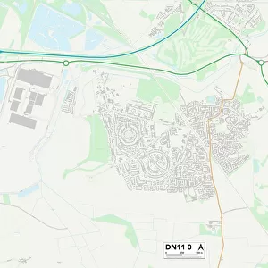
Doncaster DN6 8 Map

![]()
Wall Art and Photo Gifts from Map Marketing
Doncaster DN6 8 Map
Postcode Sector Map of Doncaster DN6 8
Media ID 19968516
Acacia Road Ash Road Beech Road Birch Avenue Borrowdale Close Briar Road Buttermere Close Chapel Street Charles Street Chestnut Avenue Coal Pit Lane Cromwell Court Cross Hill Crossfield Drive Doncaster Edward Road Elm Road French Street George Street Grange Lane Grasmere Road Green Lane Hawthorne Crescent High Street Humber Close Ings Lane Langdale Road Laurel Terrace Leyburn Road Leys Lane Lodge Road Mansfield Crescent Markham Avenue Mill Lane Milton Road New Street Newlands Avenue Old Hall Road Park Avenue Patterdale Close Poplar Road Queens Road Repton Road Rydal Road Sherwood Drive Station Road Straight Lane The Grange Trafalgar Street Victor Street Willington Road Willowbrook Windermere Close
FEATURES IN THESE COLLECTIONS
> Arts
> Artists
> G
> Charles Green
> Map Marketing
> Postcode Sector Maps
> DN - Doncaster
> Maps and Charts
> Related Images
MADE IN THE USA
Safe Shipping with 30 Day Money Back Guarantee
FREE PERSONALISATION*
We are proud to offer a range of customisation features including Personalised Captions, Color Filters and Picture Zoom Tools
SECURE PAYMENTS
We happily accept a wide range of payment options so you can pay for the things you need in the way that is most convenient for you
* Options may vary by product and licensing agreement. Zoomed Pictures can be adjusted in the Cart.