Home > Europe > United Kingdom > Scotland > Edinburgh > Edinburgh
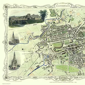
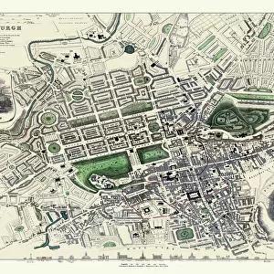
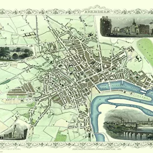
Old Map of Edinburgh and Leith 1864 by G. W. Swanson

![]()
Wall Art and Photo Gifts from MapSeeker
Old Map of Edinburgh and Leith 1864 by G. W. Swanson
Splendid reproduction map of Edinburgh originally drawn and engraved by G.H.Swanson. The plan of Edinburgh and Leith shows exceptional detail. Buildings are finely drawn with important buildings such as the castle displayed in block ink. The early railways, along with all roads are named. At the top of the plan there is the Firth of Forth along with its piers, harbour and docks. At the bottom of the map even the smallest of residences of Morningside are detailed and in many cases named
Welcome to the Mapseeker Image library and enter an historic gateway to one of the largest on-line collections of Historic Maps, Nostalgic Views, Vista's and Panorama's from a World gone by.
Media ID 20347174
Edinburgh Historic Map Old Town Plan Edinburgh City
FEATURES IN THESE COLLECTIONS
> Arts
> Photorealistic artworks
> Detailed art pieces
> Masterful detailing in art
> Europe
> United Kingdom
> Heritage Sites
> Old and New Towns of Edinburgh
> Europe
> United Kingdom
> Scotland
> Edinburgh
> Edinburgh
> Europe
> United Kingdom
> Scotland
> Lothian
> Edinburgh
> Historic
> Medieval architecture
> Castles and fortresses
> Historic castles
> Maps and Charts
> Early Maps
> Maps and Charts
> Related Images
> MapSeeker
> British Town And City Plans
> Scottish PORTFOLIO
> Popular Themes
> Railway Posters
EDITORS COMMENTS
This splendid reproduction print of the "Old Map of Edinburgh and Leith 1864" by G. W. Swanson takes us on a captivating journey through time. Originally drawn and engraved by G. H. Swanson, this map is a true work of art that showcases exceptional detail. As we explore the plan of Edinburgh and Leith, we are immediately struck by the meticulous craftsmanship displayed in every aspect. The buildings are finely drawn, with prominent landmarks like the majestic castle standing out boldly in block ink. This attention to detail allows us to envision what life must have been like in this historic city over a century ago. The map not only highlights architectural wonders but also provides valuable insights into transportation networks. Early railways crisscrossing the landscape are clearly labeled, alongside all major roads leading to and from Edinburgh. This comprehensive depiction offers a glimpse into how people moved about during that era. At both ends of the map, we encounter significant features: at the top lies the Firth of Forth with its piers, harbor, and docks—a reminder of Edinburgh's maritime heritage; while at the bottom even the smallest residences in Morningside are meticulously detailed and named—an ode to every corner of this vibrant city. Whether you're an avid history enthusiast or simply curious about old maps, this remarkable piece will transport you back in time as you immerse yourself in its intricate beauty. Discover for yourself why Edinburgh has always captivated hearts with its rich history and undeniable charm through this extraordinary "Old Map. "
MADE IN THE USA
Safe Shipping with 30 Day Money Back Guarantee
FREE PERSONALISATION*
We are proud to offer a range of customisation features including Personalised Captions, Color Filters and Picture Zoom Tools
SECURE PAYMENTS
We happily accept a wide range of payment options so you can pay for the things you need in the way that is most convenient for you
* Options may vary by product and licensing agreement. Zoomed Pictures can be adjusted in the Cart.