Home > Animals > Fishes > P > Perch
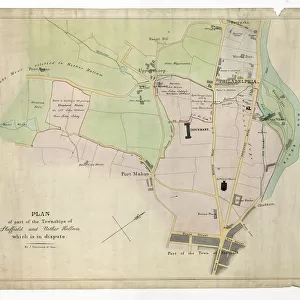
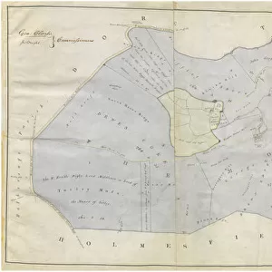
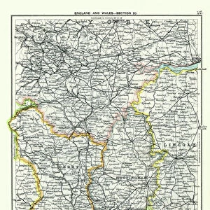
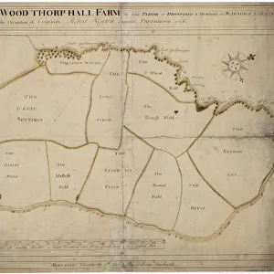
Map of Woodthorpe Hall Farm [Holmesfield] in the parish of Dronfield, County of Derby, 1736
![Map of Woodthorpe Hall Farm [Holmesfield] in the parish of Dronfield, County of Derby, 1736](/p/716/map-woodthorpe-hall-farm-holmesfield-parish-18987347.jpg.webp "Map of Woodthorpe Hall Farm [Holmesfield] in the parish of Dronfield, County of Derby, 1736")
![]()
Wall Art and Photo Gifts from Sheffield City Archives
Map of Woodthorpe Hall Farm [Holmesfield] in the parish of Dronfield, County of Derby, 1736
Full title: map of Woodthorpe Hall Farm [Holmesfield] in the parish of Dronfield and Hundred of Scarsdale and County of Derby, in the occupation of J. Greaves, Robert Newton proprietor.
Surveyed by William Fairbank.
Scale 80 perches : 20 inches.
Includes the Great Settings, the Little Settings, the Long Field, the Barley Field, The Croft (house), The Mistress Field, the road to Totley, Dore and Sheffield, the Stone Pit Field, the Round Field, the Rough Field, the Bitts, and The Nether Ley.
Dimensions: 89 x 65 cm.
From an original at Sheffield Libraries; arc02925a
Sheffield City Archives and Local Studies Library has an unrivalled collection of images of Sheffield, England
Media ID 18987347
FEATURES IN THESE COLLECTIONS
> Animals
> Fishes
> P
> Perch
> Animals
> Insects
> Hemiptera
> Hall Scale
> Arts
> Artists
> D
> William Derby
> Arts
> Artists
> F
> Newton Fielding
> Europe
> United Kingdom
> England
> Derbyshire
> Derby
> Europe
> United Kingdom
> England
> Derbyshire
> Dronfield
> Europe
> United Kingdom
> England
> Derbyshire
> Holmesfield
> Europe
> United Kingdom
> England
> Derbyshire
> Newton
> Europe
> United Kingdom
> England
> Derbyshire
> Related Images
> Sheffield City Archives
> Maps and Plans
> Maps of Derbyshire
EDITORS COMMENTS
This print showcases the intricate "Map of Woodthorpe Hall Farm" in Holmesfield, a picturesque village nestled within the parish of Dronfield, County of Derby. Created in 1736 by the skilled surveyor William Fairbank, this map offers a fascinating glimpse into the agricultural landscape of that era. Spanning an impressive 89 x 65 cm, this meticulously detailed map highlights various features and landmarks within Woodthorpe Hall Farm. From the sprawling Great Settings and Little Settings to the vast Long Field and Barley Field, every inch is carefully documented. The Croft, a charming house at its heart, stands as a testament to timeless architecture. The map also captures key transportation routes such as the road leading to Totley, Dore, and Sheffield – bustling towns that were undoubtedly vital for trade during those times. Additionally, it delineates significant fields like the Stone Pit Field, Round Field, Rough Field, Bitts (perhaps referring to grazing areas), and The Nether Ley. Preserved from an original document housed at Sheffield Libraries under reference arc02925a; this remarkable print allows us to appreciate both historical cartography techniques and gain insight into how land was utilized centuries ago. It serves as a valuable resource for historians and enthusiasts alike who wish to explore Woodthorpe Hall Farm's rich heritage in Derbyshire's scenic countryside.
MADE IN THE USA
Safe Shipping with 30 Day Money Back Guarantee
FREE PERSONALISATION*
We are proud to offer a range of customisation features including Personalised Captions, Color Filters and Picture Zoom Tools
SECURE PAYMENTS
We happily accept a wide range of payment options so you can pay for the things you need in the way that is most convenient for you
* Options may vary by product and licensing agreement. Zoomed Pictures can be adjusted in the Cart.
![Woodthorpe [Holmsfield], Dronfield, Derbyshire, 1741](/sq/716/woodthorpe-holmsfield-dronfield-derbyshire-14045377.jpg.webp)