Home > Animals > Mammals > Muridae > House Mouse
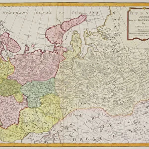
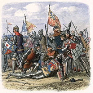
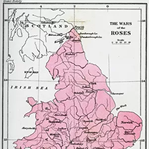
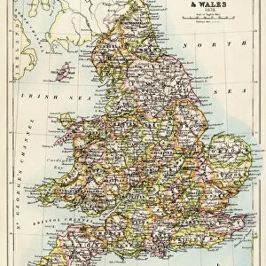
Map of the Wars of the Roses, 15th century (1893)
")
![]()
Wall Art and Photo Gifts from Heritage Images
Map of the Wars of the Roses, 15th century (1893)
Map of the Wars of the Roses, 15th century (1893). The Wars of the Roses was a civil war fought over the throne of England between adherents of the House of Lancaster and the House of York. The intermittent conflict lasted from 1455 until the decisive defeat of Richard III by Henry Tudor at Bosworth Field in 1485. An illustration from A Short History of the English People, by John Richard Green, illustrated edition, Volume II, Macmillan and Co, London, New York, 1893
Heritage Images features heritage image collections
Media ID 14925530
© The Print Collector / Heritage-Images
1455 1485 Cartography Civil War House Of Lancaster House Of York John Richard John Richard Green Map Making Power Struggle Wales War Of The Roses Wars Of The Roses
FEATURES IN THESE COLLECTIONS
> Animals
> Mammals
> Muridae
> House Mouse
> Arts
> Art Movements
> Medieval Art
> Arts
> Artists
> F
> John Field
> Arts
> Artists
> S
> Richard Short
> Europe
> United Kingdom
> England
> Lancaster
> Europe
> United Kingdom
> England
> London
> Royalty
> Europe
> United Kingdom
> England
> Maps
> Europe
> United Kingdom
> England
> York
> Europe
> United Kingdom
> Wales
> Maps
> Europe
> United Kingdom
> Wales
> Posters
EDITORS COMMENTS
This 19th-century print showcases a meticulously detailed map of the Wars of the Roses, a tumultuous and pivotal period in English history. Created in 1893 by an unknown artist, this map provides a visual representation of the power struggle that took place between the House of Lancaster and the House of York during the 15th century. The vibrant colors used in this print bring to life the geographical locations involved in this civil war, spanning across England and Wales. With its intricate cartography, it allows us to delve into medieval England and witness firsthand how these rival factions fought for control over the throne. As we explore this historical artifact, we are transported back to a time when royalty clashed and kingdoms were at stake. The wars lasted for three decades until Henry Tudor's decisive victory over Richard III at Bosworth Field in 1485. Originally featured as an illustration in John Richard Green's A Short History of the English People, Volume II, published by Macmillan & Co. , London and New York, this print serves as both an educational tool and a testament to our fascination with medieval conflicts. With every line carefully etched on paper by skilled hands from centuries ago, this map reminds us not only of our past but also highlights how far we have come as a nation. It is through such historical artifacts that we can appreciate our rich heritage while gaining insights into significant events that shaped our present-day society.
MADE IN THE USA
Safe Shipping with 30 Day Money Back Guarantee
FREE PERSONALISATION*
We are proud to offer a range of customisation features including Personalised Captions, Color Filters and Picture Zoom Tools
SECURE PAYMENTS
We happily accept a wide range of payment options so you can pay for the things you need in the way that is most convenient for you
* Options may vary by product and licensing agreement. Zoomed Pictures can be adjusted in the Cart.