Home > Africa > Egypt > Maps
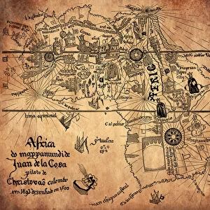
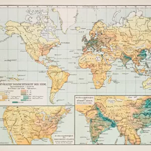
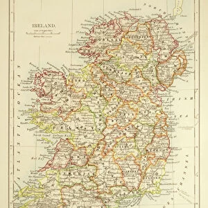
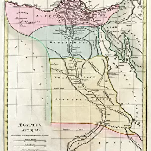
Old map of Africa 1856

![]()
Wall Art and Photo Gifts from Fine Art Storehouse
Old map of Africa 1856
Colton and Fitchs Modern School Geography by George W. Fitch - New York 1856
Unleash your creativity and transform your space into a visual masterpiece!
THEPALMER
Media ID 13668741
© Roberto A Sanchez
Egypt Ethiopia Horn Of Africa Indian Ocean Middle East Obsolete
FEATURES IN THESE COLLECTIONS
> Africa
> Egypt
> Related Images
> Africa
> Ethiopia (Abyssinia)
> Related Images
> Africa
> Ethiopia
> Related Images
> Africa
> Related Images
> Arts
> Artists
> I
> Indian School Indian School
> Arts
> Artists
> O
> Oceanic Oceanic
> Fine Art Storehouse
> The Magical World of Illustration
> Palmer Illustrated Collection
> Fine Art Storehouse
> Map
> Historical Maps
> Maps and Charts
> Related Images
EDITORS COMMENTS
In this print, we are transported back in time to the year 1856, where an old map of Africa takes center stage. A relic from the past, this engraved image showcases the intricate artistry and attention to detail that went into cartography during that era. The map is a part of "Colton and Fitch's Modern School Geography" by George W. Fitch, a renowned geographer from New York. As we explore this historical piece, our eyes are drawn to the vast continent of Africa sprawled before us. From Ethiopia to Egypt, every corner is meticulously depicted with precision and accuracy. The Indian Ocean glistens nearby as it connects Africa with other parts of the world. The vertical orientation allows us to delve deeper into Africa's physical geography, revealing its diverse landscapes and natural wonders. We can almost imagine traversing through its expansive deserts or navigating along its winding rivers. Notably, our gaze lingers on the Horn of Africa region - a strategic location bridging continents and cultures throughout history. This illustration serves as a reminder of how ancient civilizations flourished in these lands long before modern borders were established. This print by THEPALMER not only captures a moment frozen in time but also invites us to reflect on how our understanding of geography has evolved over centuries. It stands as both an educational tool for students in 1856 and a cherished piece for collectors today who appreciate the beauty found within obsolete maps like these.
MADE IN THE USA
Safe Shipping with 30 Day Money Back Guarantee
FREE PERSONALISATION*
We are proud to offer a range of customisation features including Personalised Captions, Color Filters and Picture Zoom Tools
SECURE PAYMENTS
We happily accept a wide range of payment options so you can pay for the things you need in the way that is most convenient for you
* Options may vary by product and licensing agreement. Zoomed Pictures can be adjusted in the Cart.