Home > Europe > United Kingdom > Wales > Maps
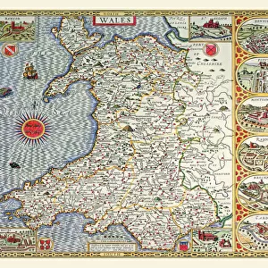
Old County Map of Flintshire 1611 by John Speed

![]()
Wall Art and Photo Gifts from MapSeeker
Old County Map of Flintshire 1611 by John Speed
A facimile of John Speeds historical map of Flintshire originally published for the " Theatre of the Empire of Great Britain", an atlas to accompany " a history of Great Britain"
Welcome to the Mapseeker Image library and enter an historic gateway to one of the largest on-line collections of Historic Maps, Nostalgic Views, Vista's and Panorama's from a World gone by.
Media ID 20347735
© Mapseeker Publishing Ltd
County Map County Map Of Wales Historic Map John Speed Map Old County Map Old Welsh County Map Speed Map Speede Map Welsh County Map Flintshire
FEATURES IN THESE COLLECTIONS
> Arts
> Artists
> S
> John Speed
> Europe
> United Kingdom
> Wales
> Flintshire
> Related Images
> Europe
> United Kingdom
> Wales
> Maps
> Europe
> United Kingdom
> Wales
> Posters
> Europe
> United Kingdom
> Wales
> Related Images
> Maps and Charts
> British Empire Maps
> Maps and Charts
> Early Maps
> Maps and Charts
> Wales
> MapSeeker
> Maps from the British Isles
> Wales and Counties PORTFOLIO
EDITORS COMMENTS
This print showcases the remarkable "Old County Map of Flintshire 1611" by the renowned cartographer John Speed. A true gem for history enthusiasts, this facsimile of Speed's original map was initially published as part of his monumental work, "The Theatre of the Empire of Great Britain". Serving as an accompanying atlas to a comprehensive history of Great Britain, this map offers a fascinating glimpse into Flintshire's past. With its intricate details and exquisite craftsmanship, this old Welsh county map transports us back in time to the early 17th century. The carefully drawn boundaries and meticulously labeled towns and villages provide a valuable resource for understanding the historical landscape of Flintshire. As we explore its faded contours, we can almost imagine ourselves traversing through ancient roads and pathways that once connected these communities. Flintshire's rich heritage comes alive through this historic map, shedding light on its significance within Wales' broader context. From bustling market towns to serene rural landscapes, every corner is captured with precision and artistry. Whether you are a scholar delving into local history or simply captivated by antique maps, this piece serves as both an educational tool and a stunning display item. As we admire John Speed's masterful creation in all its glory, let us appreciate how it connects us to generations long gone while reminding us that even centuries later, their stories continue to shape our present-day understanding of Flintshire and beyond.
MADE IN THE USA
Safe Shipping with 30 Day Money Back Guarantee
FREE PERSONALISATION*
We are proud to offer a range of customisation features including Personalised Captions, Color Filters and Picture Zoom Tools
SECURE PAYMENTS
We happily accept a wide range of payment options so you can pay for the things you need in the way that is most convenient for you
* Options may vary by product and licensing agreement. Zoomed Pictures can be adjusted in the Cart.