Home > Architecture > Country > Italy > Rome
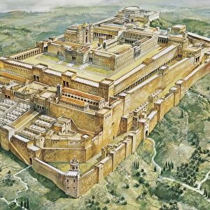
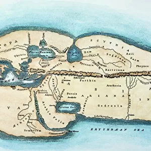
Map of the Servian wall, constructed around the city of Rome in the early 4th century BC, drawing

![]()
Wall Art and Photo Gifts from Universal Images Group (UIG)
Map of the Servian wall, constructed around the city of Rome in the early 4th century BC, drawing
Cartography - Roman Civilization - Italy - Latium region - Rome. Map of the Servian wall, constructed around the city of Rome in the early 4th century b.C. Drawing
Universal Images Group (UIG) manages distribution for many leading specialist agencies worldwide
Media ID 9512865
Aerial View Capital Cities Colored Background Defense Drawing Fortified Wall River Rome Defensive Wall
FEATURES IN THESE COLLECTIONS
> Architecture
> Country
> Italy
> Rome
> Architecture
> Drawings
> Architecture
> Styles
> Roman Architecture
> Arts
> Landscape paintings
> Waterfall and river artworks
> River artworks
> Europe
> Italy
> Aerial Views
> Europe
> Italy
> Lazio
> Rome
> Universal Images Group (UIG)
> Art
> Archeology
EDITORS COMMENTS
This print showcases a detailed map of the Servian wall, an ancient defensive structure constructed around the city of Rome in the early 4th century BC. The drawing, created with precision and artistry, offers a fascinating glimpse into Roman civilization and Italy's rich history. The aerial view depicted in this square image allows us to appreciate the architectural brilliance of this fortified wall. Stretching across the landscape, it served as a formidable defense for the capital city of Rome. With its strategic placement along the river and colored background highlighting its significance, this map transports us back to a time when ancient civilizations sought protection from external threats. As we explore every inch of this illustration and painting, we are reminded of how far humanity has come since those days. The absence of people in this image emphasizes that it is not just about individuals but rather about understanding our collective past. This print from Universal Images Group (UIG) invites us to delve into cartography and immerse ourselves in one aspect of ancient Rome's grandeur. It serves as both an educational tool for historians and archaeologists alike while also appealing to those who appreciate artistry combined with historical accuracy
MADE IN THE USA
Safe Shipping with 30 Day Money Back Guarantee
FREE PERSONALISATION*
We are proud to offer a range of customisation features including Personalised Captions, Color Filters and Picture Zoom Tools
SECURE PAYMENTS
We happily accept a wide range of payment options so you can pay for the things you need in the way that is most convenient for you
* Options may vary by product and licensing agreement. Zoomed Pictures can be adjusted in the Cart.