Home > Europe > Italy > Veneto > Venice
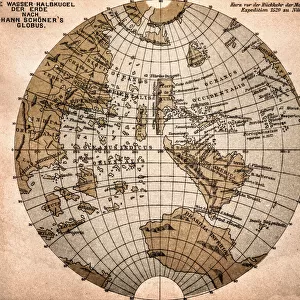
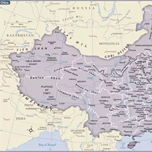
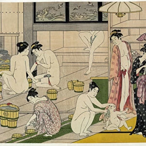
Map of the compasssole from a 16th century atlas, based on the original preserved in the library of the Museo Civico in Venice

![]()
Wall Art and Photo Gifts from Fine Art Finder
Map of the compasssole from a 16th century atlas, based on the original preserved in the library of the Museo Civico in Venice
LSE4102206 Map of the compasssole from a 16th century atlas, based on the original preserved in the library of the Museo Civico in Venice by Italian School, (16th century) (after); Private Collection; (add.info.: Map of the compasssole from a 16th century atlas, based on the original preserved in the library of the Museo Civico in Venice); Photo © Leonard de Selva
Media ID 26407276
© Leonard de Selva / Bridgeman Images
China China China China Chinese Compas Asian Asian Chineses Geographical Map
FEATURES IN THESE COLLECTIONS
> Arts
> Artists
> I
> Italian School Italian School
> Asia
> Related Images
> Europe
> Italy
> Related Images
> Europe
> Italy
> Veneto
> Venice
> Fine Art Finder
> Artists
> Jean (after) Froissart
> Fine Art Finder
> Schools
> Italian School
> Maps and Charts
> Early Maps
> Maps and Charts
> Italy
> Maps and Charts
> Related Images
EDITORS COMMENTS
This print showcases a remarkable map of the compasssole from a 16th-century atlas, based on the original preserved in the library of the Museo Civico in Venice. The intricate engraving, created by an unknown Italian School artist during the 16th century, offers a glimpse into the geographical knowledge and exploration of that era. The map itself is a testament to both European and Asian influences. It combines elements of Chinese cartography with Western techniques, reflecting the exchange of knowledge between these two regions during this period. The detailed depiction of Asia highlights its significance as a center for trade and cultural exchange. The compasssole featured in this map serves as a vital navigational tool for sailors venturing into uncharted territories. Its inclusion emphasizes not only practicality but also symbolizes humanity's insatiable curiosity to explore new horizons. Leonard de Selva's expert photography captures every minute detail with precision and clarity, allowing viewers to appreciate both the artistry and historical importance of this rare artifact. This print transports us back in time, offering an opportunity to marvel at how our understanding of geography has evolved over centuries. Whether you are an enthusiast for ancient maps or simply fascinated by history's intercontinental connections, this striking image will undoubtedly captivate your imagination and inspire further exploration into our shared past.
MADE IN THE USA
Safe Shipping with 30 Day Money Back Guarantee
FREE PERSONALISATION*
We are proud to offer a range of customisation features including Personalised Captions, Color Filters and Picture Zoom Tools
SECURE PAYMENTS
We happily accept a wide range of payment options so you can pay for the things you need in the way that is most convenient for you
* Options may vary by product and licensing agreement. Zoomed Pictures can be adjusted in the Cart.