Home > Europe > United Kingdom > England > Kent > Sittingbourne
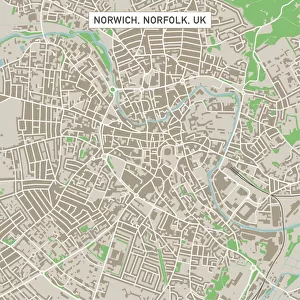
Sittingbourne Kent UK City Street Map

![]()
Wall Art and Photo Gifts from Fine Art Storehouse
Sittingbourne Kent UK City Street Map
Vector Illustration of a City Street Map of Sittingbourne, Kent, UK. Included files are EPS (v10) and Hi-Res JPG.
Data courtesy from Ordnance Survey: VectorMap District
https:/ordnancesurvey.co.uk/business-and-government/products/vectormap-district.html
OS OpenData is free to use under the Open Government Licence (OGL).
Contains OS data eCrown copyright and database right 2017.
http:/nationalarchives.gov.uk/doc/open-government-licence/version/3/
Unleash your creativity and transform your space into a visual masterpiece!
Frank Ramspott
Media ID 15055239
© Frank Ramspott, all rights reserved
Aerial View Computer Graphic Directly Above Gray Green Kent Road Map Street Map Text Digitally Generated Image Sittingbourne The Swale
FEATURES IN THESE COLLECTIONS
> Aerial Photography
> Related Images
> Arts
> Contemporary art
> Digital artwork
> Street art
> Arts
> Portraits
> Pop art gallery
> Street art portraits
> Arts
> Street art graffiti
> Digital art
> Digital paintings
> Arts
> Street art graffiti
> Digital art
> Vector illustrations
> Europe
> United Kingdom
> England
> Kent
> Green Street Green
> Europe
> United Kingdom
> England
> Kent
> Kent Street
> Europe
> United Kingdom
> England
> Kent
> Sittingbourne
> Europe
> United Kingdom
> Maps
> Fine Art Storehouse
> Map
> Street Maps
> Maps and Charts
> Related Images
EDITORS COMMENTS
This print showcases a detailed and beautifully designed city street map of Sittingbourne, Kent in the United Kingdom. Created as a vector illustration, this artwork is both visually appealing and informative. The print includes EPS (v10) and Hi-Res JPG files, ensuring high-quality reproduction. The data used to create this map is courtesy of Ordnance Survey's VectorMap District, a reliable source for accurate geographic information. It is worth noting that OS OpenData allows free usage under the Open Government Licence (OGL), with eCrown copyright and database right applicable from 2017. The image itself presents an aerial view directly above Sittingbourne, capturing its streets, roads, buildings, and town layout with precision. The color scheme features shades of gray, green, blue, and white which add depth to the overall design. With no people present in the digitally generated image, the focus remains solely on the intricate cartography displayed. This print by Frank Ramspott offers an artistic representation of Sittingbourne's physical geography while serving as an excellent addition to any space seeking a touch of sophistication and local pride.
MADE IN THE USA
Safe Shipping with 30 Day Money Back Guarantee
FREE PERSONALISATION*
We are proud to offer a range of customisation features including Personalised Captions, Color Filters and Picture Zoom Tools
SECURE PAYMENTS
We happily accept a wide range of payment options so you can pay for the things you need in the way that is most convenient for you
* Options may vary by product and licensing agreement. Zoomed Pictures can be adjusted in the Cart.