Home > Europe > United Kingdom > England > London > Towns > Welling
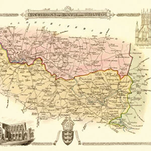
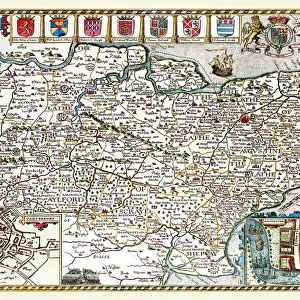
Old Map of the Environs of Portsmouth 1836 by Thomas Moule

![]()
Wall Art and Photo Gifts from MapSeeker
Old Map of the Environs of Portsmouth 1836 by Thomas Moule
This is a fine decorative reproduction Map of The Environs of Portsmouth from the First Edition series of Thomas Moule Maps, originally Published in 1836. The well-known series of County Maps which are known as Moules feature beautiful vignette views, there were also 4 " Environs" Maps included, and were first published in separate sections for each county in 1830-32, they were then published in collected form in a two-volume work: The English Counties Delineated: or a Topographical Description of England: Illustrated by a Complete Series of County Maps by Thomas Moule: London: Published by George Virtue 1836
Welcome to the Mapseeker Image library and enter an historic gateway to one of the largest on-line collections of Historic Maps, Nostalgic Views, Vista's and Panorama's from a World gone by.
Media ID 20348070
© Mapseeker Publishing Ltd
Historic Map Moule Map Old Moule Map Thomas Moule Thomas Moule Map Portsmouth
FEATURES IN THESE COLLECTIONS
> Arts
> Artists
> M
> Thomas Moule
> Europe
> United Kingdom
> England
> London
> Towns
> Welling
> Europe
> United Kingdom
> England
> Maps
> Europe
> United Kingdom
> England
> Portsmouth
> Europe
> United Kingdom
> England
> Wells
> Maps and Charts
> Related Images
> MapSeeker
> British Town And City Plans
> English & Welsh PORTFOLIO
> MapSeeker
> Maps from the British Isles
> England and Counties PORTFOLIO
EDITORS COMMENTS
This exquisite print showcases the "Old Map of the Environs of Portsmouth 1836" by Thomas Moule, a renowned cartographer of his time. Originally published in 1836 as part of Moule's esteemed County Maps series, this reproduction map offers a captivating glimpse into the historic charm and topography surrounding Portsmouth. Moule's meticulous attention to detail is evident in this map, featuring intricate vignette views that add an artistic touch to its overall allure. The inclusion of four "Environs". Maps further enhances its value as a comprehensive depiction of the region during that era. Published by George Virtue in London, this particular edition holds significant historical significance. It was first released as separate sections for each county between 1830 and 1832 before being compiled into a two-volume masterpiece titled "The English Counties Delineated: or a Topographical Description of England". As you explore this mesmerizing piece, immerse yourself in the rich history and heritage it unveils. From tracing the streets and landmarks that shaped old Portsmouth to discovering hidden gems within its environs, let your imagination transport you back to an era long gone. Whether you are an avid collector or simply appreciate fine decorative reproductions, this stunning print is sure to captivate both your eyes and soul with its timeless beauty. Let Thomas Moule's masterful artistry guide you through the enchanting world of historic maps and rediscover the allure of Portsmouth's past.
MADE IN THE USA
Safe Shipping with 30 Day Money Back Guarantee
FREE PERSONALISATION*
We are proud to offer a range of customisation features including Personalised Captions, Color Filters and Picture Zoom Tools
SECURE PAYMENTS
We happily accept a wide range of payment options so you can pay for the things you need in the way that is most convenient for you
* Options may vary by product and licensing agreement. Zoomed Pictures can be adjusted in the Cart.