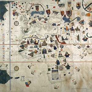
Chart by Juan de la Cosa (1500). SPAIN. Madrid
. SPAIN. Madrid")
![]()
Wall Art and Photo Gifts from Mary Evans Picture Library
Chart by Juan de la Cosa (1500). SPAIN. Madrid
Chart by Juan de la Cosa (1500). SPAIN. Madrid. Navy Museum
Mary Evans Picture Library makes available wonderful images created for people to enjoy over the centuries
Media ID 8275163
© Mary Evans Picture Library 2015 - https://copyrighthub.org/s0/hub1/creation/maryevans/MaryEvansPictureID/10683537
Artistic Beaux C Ulture Cartographic Cartographies Cartography Chart Cosa Geographic Geographical Geography Juan Maps Navigation Sail
EDITORS COMMENTS
This stunning chart, created by the Spanish cartographer Juan de la Cosa in 1500, is a testament to the rich maritime history of Spain during the Age of Discovery. Housed in the Navy Museum in Madrid, this exquisite piece of cartography is a fine example of the artistic and geographical advancements made during this period of intensive navigation and exploration. The chart, which measures approximately 1.2 meters in diameter, is adorned with intricate illustrations of various coastal regions and islands, meticulously detailed and colorfully rendered. The map covers the western Atlantic Ocean, from the northernmost tip of Europe to the southernmost tip of South America. It includes the Iberian Peninsula, the Canary Islands, the coasts of North and South America, and the Caribbean islands. Juan de la Cosa, a navigator and cartographer in the service of the Spanish Crown, created this chart to aid in the exploration and conquest of new lands. The chart's accuracy and detail were crucial for the success of Spanish expeditions, as they allowed navigators to plot their courses and identify potential ports and harbors. This chart is a significant cultural artifact, showcasing the interconnectedness of the world during the Age of Discovery. It reflects the Spanish Empire's growing influence and dominance in the Atlantic world, as well as the advancements made in cartography and navigation during this period. The intricate illustrations and precise cartography demonstrate the artistic and geographical achievements of Juan de la Cosa and his contemporaries, making this chart a valuable addition to the collections of the Navy Museum in Madrid.
MADE IN THE USA
Safe Shipping with 30 Day Money Back Guarantee
FREE PERSONALISATION*
We are proud to offer a range of customisation features including Personalised Captions, Color Filters and Picture Zoom Tools
SECURE PAYMENTS
We happily accept a wide range of payment options so you can pay for the things you need in the way that is most convenient for you
* Options may vary by product and licensing agreement. Zoomed Pictures can be adjusted in the Cart.