Home > Animals > Mammals > Didelphidae > Formosa
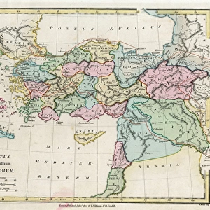
Map of Asia circa 1810

![]()
Wall Art and Photo Gifts from Mary Evans Picture Library
Map of Asia circa 1810
Map of Asia circa 1810. Handcoloured copperplate engraving by Andrea Bernieri from Giulio Ferrarios Ancient and Modern Costumes of all the Peoples of the World, Florence, Italy, 1843
Mary Evans Picture Library makes available wonderful images created for people to enjoy over the centuries
Media ID 23172820
© Florilegius/Mary Evans
Arabia Ferrario Formosa Giulio Korea Peoples Persia Taiwan
FEATURES IN THESE COLLECTIONS
> Animals
> Mammals
> Didelphidae
> Formosa
> Arts
> Artists
> F
> Giulio Ferrario
> Asia
> Japan
> Related Images
> Asia
> Related Images
> Asia
> Taiwan
> Related Images
> Mary Evans Prints Online
> New Images August 2021
EDITORS COMMENTS
This handcoloured copperplate engraving, created by Andrea Bernieri in 1810 as part of Giulio Ferrario's "Ancient and Modern Costumes of all the Peoples of the World," offers a fascinating glimpse into the geographical knowledge of Asia during the early 19th century. The map meticulously depicts the various regions and territories of Asia, including China, Tartaria (Mongolia), Arabia, Persia, Japan, Korea, Taiwan, and Formosa (Taiwan). The intricate detail and vibrant colours bring the map to life, with each territory delicately shaded and labelled in elegant script. The Red River, the Ganges, and the Indus are among the major waterways depicted, while the Silk Road and other important trade routes are also indicated. At the time, Asia was a region of immense cultural and political significance, with various empires and dynasties vying for power and influence. This map reflects the growing European interest in the region, as well as the expanding reach of European exploration and cartography. Despite the advances in cartography, the map also reveals the limitations of knowledge at the time. For instance, the border between China and Tibet is not clearly defined, and the location of some smaller islands in the Pacific is uncertain. Nevertheless, the map remains an important historical document, providing valuable insights into the geographical understanding of Asia during the early 19th century. The map's intricate design and rich detail make it an attractive addition to any collection of historical maps or illustrations. Its age and rarity add to its allure, making it a prized possession for scholars, historians, and collectors alike.
MADE IN THE USA
Safe Shipping with 30 Day Money Back Guarantee
FREE PERSONALISATION*
We are proud to offer a range of customisation features including Personalised Captions, Color Filters and Picture Zoom Tools
SECURE PAYMENTS
We happily accept a wide range of payment options so you can pay for the things you need in the way that is most convenient for you
* Options may vary by product and licensing agreement. Zoomed Pictures can be adjusted in the Cart.