Home > Europe > Italy > Veneto > Venice
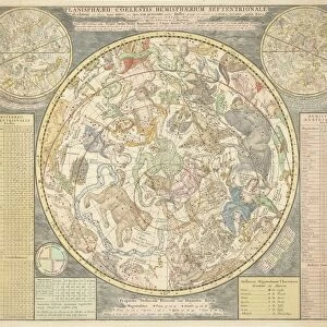
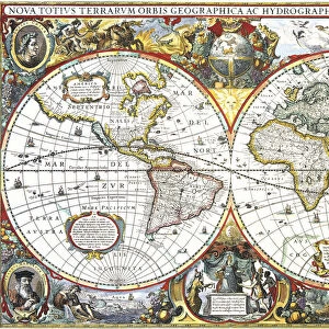
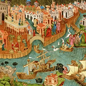
Haci Ahmeds world map, 1560

![]()
Wall Art and Photo Gifts from Science Photo Library
Haci Ahmeds world map, 1560
Haci Ahmeds world map. This map, based on Oronce Fines cordiform (heart-shaped) map of 1534, was translated into Turkish in the Islamic year 967 (October 1559 to September 1560). The author, Haci Ahmed is thought to be a pseudonym of the Venetian traveller Michele Membre and the interpreter Nicolo Cambi. The map may have been provided for Ottoman princes, as part of cultural and political exchanges between the two states. This copy was printed in 1795 from woodcut blocks found in the archives of the Council of Ten in Venice, Italy. The illustrations include two celestial hemispheres (lower left and lower right) and an armillary sphere (lower centre)
Science Photo Library features Science and Medical images including photos and illustrations
Media ID 6298165
© LIBRARY OF CONGRESS, GEOGRAPHY AND MAP DIVISION/SCIENCE PHOTO LIBRARY
1500s 16th Century 18th Century Age Of Discovery Armillary Sphere C Ulture Cartographic Cartography Celestial Sphere Dutch Flemish Gift Global Heart Shaped Islamic Mediaeval Medieval Middle Ages Ottoman Empire Text Translation Turkish Venetian Venice Wind Winds Wood Cut World World Wide Writing 1560 1795 Ambassadorial Mono Chrome Oronce Fine Translated Turkic
FEATURES IN THESE COLLECTIONS
> Arts
> Art Movements
> Medieval Art
> Asia
> Turkey
> Related Images
> Europe
> Italy
> Related Images
> Europe
> Italy
> Veneto
> Venice
> Europe
> Related Images
> Maps and Charts
> Early Maps
> Maps and Charts
> Italy
EDITORS COMMENTS
This print showcases Haci Ahmed's world map, a remarkable piece of cartographic art from 1560. The origins of this map trace back to Oronce Fines cordiform (heart-shaped) map of 1534, which was later translated into Turkish in the Islamic year 967. It is believed that Haci Ahmed, the credited author, may have been a pseudonym for Venetian traveler Michele Membre and interpreter Nicolo Cambi. The significance of this particular copy lies in its printing date of 1795, using woodcut blocks discovered in the archives of Venice's Council of Ten. This suggests that it might have been created as a gift for Ottoman princes during cultural and political exchanges between these two states. The intricately illustrated map includes celestial hemispheres and an armillary sphere, providing a comprehensive depiction of the world during the 16th century. Its monochrome aesthetic adds to its historical charm and transports us back to an era when exploration and discovery were at their peak. With references to various cultures such as Dutch, Flemish, Islamic, and Venetian influences, this artwork symbolizes cross-cultural exchange during the Age of Discovery. It serves as both a testament to human curiosity about our planet's geography and a reminder of how knowledge transcends borders. Science Photo Library presents this image with utmost care for historical accuracy and appreciation for its artistic value.
MADE IN THE USA
Safe Shipping with 30 Day Money Back Guarantee
FREE PERSONALISATION*
We are proud to offer a range of customisation features including Personalised Captions, Color Filters and Picture Zoom Tools
SECURE PAYMENTS
We happily accept a wide range of payment options so you can pay for the things you need in the way that is most convenient for you
* Options may vary by product and licensing agreement. Zoomed Pictures can be adjusted in the Cart.