Home > Arts > Landscape paintings > Waterfall and river artworks > Nature-inspired paintings
Eastern Himalayas, satellite image

![]()
Wall Art and Photo Gifts from Science Photo Library
Eastern Himalayas, satellite image
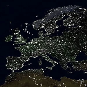
Eastern Himalayas, satellite image. North is at top. Snow is white, vegetation is red, barren areas are light blue and water is dark blue. This is a region of the eastern Himalayas, in China, north-east of Bhutan. The landscape consists of soaring mountains, with snow-capped peaks and vegetation on the lower slopes. Major rivers run through the valleys, fed by glacial meltwater. The barren areas (light blue) are where sediment has been deposited by the rivers. The area shown in this image is around 60 kilometres wide. The image data includes infrared wavelengths, and was obtained on 17 February 2002, using the ASTER sensor on the Terra satellite
Science Photo Library features Science and Medical images including photos and illustrations
Media ID 6366173
© NASA/SCIENCE PHOTO LIBRARY
2000s 2002 Advanced Spaceborne Aster China Chinese Earth Observation Earth Science February Forest From Space Frozen Geological Himalayan Himalayas Infra Red Land Montane Mountain Mountains Physical Geography Reflection Radiometer River Riverine Satellite Satellite Image Terra Thermal Emission And Valley Vegetation Winter Eastern Himalayas
FEATURES IN THESE COLLECTIONS
> Animals
> Mammals
> Muridae
> Water Mouse
> Arts
> Contemporary art
> Landscapes
> Mountain landscapes
> Arts
> Contemporary art
> Landscapes
> Nature landscapes
> Arts
> Landscape paintings
> Forest and woodland scenes
> Forest artwork
> Arts
> Landscape paintings
> Forest and woodland scenes
> Landscape paintings
> Arts
> Landscape paintings
> Forest and woodland scenes
> Nature-inspired art
> Arts
> Landscape paintings
> Landscape art
> Mountain landscapes
> Arts
> Landscape paintings
> Landscape art
> Nature-inspired artwork
> Arts
> Landscape paintings
> Waterfall and river artworks
> Landscape paintings
> Arts
> Landscape paintings
> Waterfall and river artworks
> Nature-inspired paintings
> Science Photo Library
> Aerial and Satellite
EDITORS COMMENTS
This print showcases the awe-inspiring beauty of the Eastern Himalayas, as seen from space. The image, taken by the ASTER sensor on the Terra satellite on 17 February 2002, reveals a breathtaking landscape that stretches across China's northeastern region and extends northward to Bhutan. The picture highlights the remarkable contrast between snow-capped peaks and vibrant red vegetation adorning the lower slopes of towering mountains. Majestic rivers meander through deep valleys, nourished by glacial meltwater. In areas where these rivers have deposited sediment over time, barren patches appear in a striking light blue hue. Covering an area approximately 60 kilometers wide, this satellite image captures not only visible wavelengths but also infrared ones. This additional data provides valuable insights into various aspects of Earth science and observation. Immersed in this mesmerizing scene is a sense of tranquility and grandeur that reminds us of nature's immense power and resilience. It serves as a reminder of our planet's diverse landscapes and their delicate balance. As we gaze upon this extraordinary photograph captured by Science Photo Library, we are transported to a world where icy peaks meet lush forests, where mighty rivers carve their paths through rugged terrain. It invites us to appreciate the wonders that exist beyond our everyday lives while inspiring us to protect and cherish our natural environment for generations to come.
MADE IN THE USA
Safe Shipping with 30 Day Money Back Guarantee
FREE PERSONALISATION*
We are proud to offer a range of customisation features including Personalised Captions, Color Filters and Picture Zoom Tools
SECURE PAYMENTS
We happily accept a wide range of payment options so you can pay for the things you need in the way that is most convenient for you
* Options may vary by product and licensing agreement. Zoomed Pictures can be adjusted in the Cart.