Home > Universal Images Group (UIG) > Art > Painting, Sculpture & Prints > Cartography
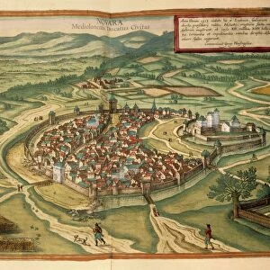
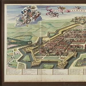
Map of Cuneo, printed in Italy, 17th Century

![]()
Wall Art and Photo Gifts from Universal Images Group (UIG)
Map of Cuneo, printed in Italy, 17th Century
Cartography, Italy, 17th century. Map of Cuneo
Universal Images Group (UIG) manages distribution for many leading specialist agencies worldwide
Media ID 9503807
© DEA PICTURE LIBRARY
17th Century Aerial View City Cityscape Cuneo Direction Field Fortified Wall Guidance Patchwork Landscape River Western Script
EDITORS COMMENTS
This print showcases a remarkable piece of cartographic history - a Map of Cuneo, printed in Italy during the 17th century. The intricate details and artistry captured within this map offer us a glimpse into the past, revealing the city's landscape, physical geography, and fortified walls. The aerial view depicted in this horizontal composition allows us to appreciate the patchwork landscape surrounding Cuneo. From lush fields to meandering rivers, each element is meticulously illustrated with precision and skill. The absence of people further emphasizes the focus on the city itself and its natural surroundings. As we examine this historical artifact, it becomes evident that this map served as more than just an artistic creation; it was a vital tool for navigation and guidance during that era. With Western script labeling various landmarks and directions, travelers could rely on these maps to navigate their way through Cuneo's streets. Beyond its practical use, however, this map also serves as a testament to human creativity and craftsmanship. The attention to detail in every stroke reveals not only technical expertise but also an appreciation for beauty in both nature and man-made structures. In conclusion, this awe-inspiring print transports us back to 17th-century Italy while offering valuable insights into Cuneo's rich history. It reminds us of how cartography played a crucial role in guiding explorers through unfamiliar territories while simultaneously celebrating artistry within scientific endeavors.
MADE IN THE USA
Safe Shipping with 30 Day Money Back Guarantee
FREE PERSONALISATION*
We are proud to offer a range of customisation features including Personalised Captions, Color Filters and Picture Zoom Tools
SECURE PAYMENTS
We happily accept a wide range of payment options so you can pay for the things you need in the way that is most convenient for you
* Options may vary by product and licensing agreement. Zoomed Pictures can be adjusted in the Cart.