Home > Aerial Photography > Italy
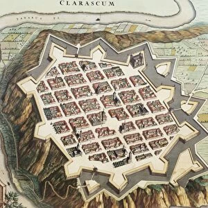
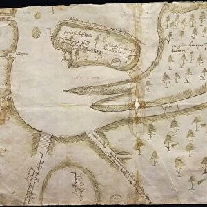
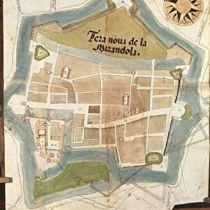
Map of Cherasco, Cuneo and its surroundings, 1720

![]()
Wall Art and Photo Gifts from Universal Images Group (UIG)
Map of Cherasco, Cuneo and its surroundings, 1720
Cartography, Italy, 18th century. Map of Cherasco, Cuneo and its surroundings in 1720
Universal Images Group (UIG) manages distribution for many leading specialist agencies worldwide
Media ID 9572067
© DEA / A. DE GREGORIO
18th Century Aerial View Cuneo Field Guidance Hill Human Settlement Mountain Navigational Equipment Old Fashioned Piedmont Text Town Western Script 1720 Non Urban Scene
FEATURES IN THESE COLLECTIONS
> Arts
> Art Movements
> Landscapes
> Arts
> Contemporary art
> Landscapes
> Sculptures
> Arts
> Contemporary art
> Sculpture
> Landscape paintings
> Arts
> Landscape paintings
> Landscape art
> Landscape paintings
> Arts
> Landscape paintings
> Landscape art
> Nature-inspired artwork
> Arts
> Landscape paintings
> Landscape art
> Arts
> Landscape paintings
> Nature-inspired artwork
> Arts
> Still life artwork
> Landscape paintings
> Nature-inspired artwork
> Universal Images Group (UIG)
> Art
> Painting, Sculpture & Prints
> Cartography
EDITORS COMMENTS
This print takes us back to the 18th century, immersing us in the rich history and topography of Cherasco, Cuneo, and its surrounding areas in Italy. The meticulously detailed map from 1720 showcases the town nestled amidst majestic mountains and rolling hills. Its old-fashioned charm is evident through the use of Western script and engraved images. The vertical composition allows for a comprehensive aerial view that reveals the landscape's natural beauty. With no people present, we are left to marvel at this non-urban scene, appreciating how human settlement harmoniously coexists with nature. As we examine this piece of art and craft closely, it becomes clear that it served as more than just an aesthetic representation. This cartographic gem was a navigational tool used by travelers seeking guidance during their journeys through Piedmont region. The map transports us to a time when technology such as navigational equipment was still in its infancy. It reminds us of our ancestors' reliance on maps like these to navigate unfamiliar territories. Through this image, we are reminded not only of Cherasco's historical significance but also of humanity's innate curiosity about our surroundings. It serves as a testament to our desire for exploration and understanding – traits that have shaped both our past and present-day world.
MADE IN THE USA
Safe Shipping with 30 Day Money Back Guarantee
FREE PERSONALISATION*
We are proud to offer a range of customisation features including Personalised Captions, Color Filters and Picture Zoom Tools
SECURE PAYMENTS
We happily accept a wide range of payment options so you can pay for the things you need in the way that is most convenient for you
* Options may vary by product and licensing agreement. Zoomed Pictures can be adjusted in the Cart.