Home > Arts > Art Movements > Baroque
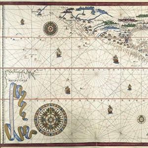
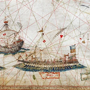
Detail of tall mast ships from the Nautical Chart by Grazioso Benincasa (Rot. 3), in the University Library of Bologna
, in the University Library of Bologna")
![]()
Wall Art and Photo Gifts from Fine Art Finder
Detail of tall mast ships from the Nautical Chart by Grazioso Benincasa (Rot. 3), in the University Library of Bologna
3565053 Detail of tall mast ships from the Nautical Chart by Grazioso Benincasa (Rot.3), in the University Library of Bologna. by Benincasa, Grazioso (fl.1468); Biblioteca Universitaria, Bologna, Italy; (add.info.: ARTIST: Benincasa, Grazioso
Date of Artwork: 1482
Location: Bologna, The Biblioteca Universitaria); Alinari Archives, Florence - Reproduced with the permission of Ministero per i Beni e le Attivita Culturali
Media ID 22444748
© Alinari Archives, Florence - Reproduced with the permission of Ministero per i Beni e le Attività Culturali / Bridgeman Images
By Water Drawing And Graphics Instrument And Document Nautical Chart Renaissance Baroque Styles And Periods Scene And Method Of Transportation University Library
FEATURES IN THESE COLLECTIONS
> Arts
> Art Movements
> Baroque
> Arts
> Art Movements
> Renaissance Art
> Arts
> Artists
> N
> Giuseppe or Joseph de Nittis
> Europe
> Italy
> Emilia-Romagna
> Bologna
> Europe
> Italy
> Tuscany
> Florence
> Fine Art Finder
> Artists
> Giuseppe or Joseph de Nittis
> Fine Art Finder
> Artists
> Grazioso Benincasa
> Historic
> Renaissance art
> Baroque art
EDITORS COMMENTS
This print showcases a mesmerizing detail of tall mast ships from the Nautical Chart by Grazioso Benincasa, housed in the prestigious University Library of Bologna. Created in 1482, this artwork is a true testament to Benincasa's artistic prowess and attention to detail. The image transports us back to the Renaissance period, with its exquisite rendering of sailboats navigating through vast waters. The intricate lines and delicate shading bring these majestic vessels to life, evoking a sense of adventure and exploration. As we delve into the scene depicted on this nautical chart, we are reminded of the crucial role it played in guiding sailors across treacherous seas. This document served as an indispensable instrument for navigation during that era, highlighting both its practicality and aesthetic appeal. Located in Bologna's esteemed Biblioteca Universitaria, this masterpiece stands as a testament to Europe's rich maritime history. It serves as a reminder of how waterways have long been vital arteries for transportation and trade throughout the continent. Through this print from Fine Art Finder by Bridgeman Images, we can appreciate not only Benincasa's skillful drawing techniques but also gain insight into the significance of geography and cartography during the Renaissance period.
MADE IN THE USA
Safe Shipping with 30 Day Money Back Guarantee
FREE PERSONALISATION*
We are proud to offer a range of customisation features including Personalised Captions, Color Filters and Picture Zoom Tools
SECURE PAYMENTS
We happily accept a wide range of payment options so you can pay for the things you need in the way that is most convenient for you
* Options may vary by product and licensing agreement. Zoomed Pictures can be adjusted in the Cart.