Home > Universal Images Group (UIG) > Art > Painting, Sculpture & Prints > Cartography
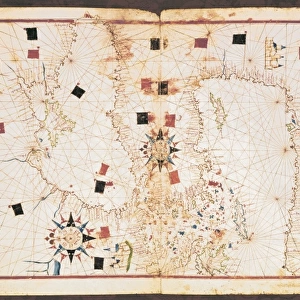
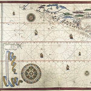
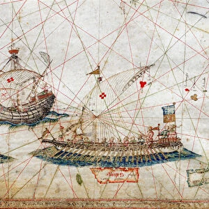
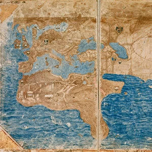
Map of Mediterranean Sea, from portolan chart by Pietro Russo, Messina, 1508

![]()
Wall Art and Photo Gifts from Universal Images Group (UIG)
Map of Mediterranean Sea, from portolan chart by Pietro Russo, Messina, 1508
Cartography, 16th century. Map of the Mediterranean Sea, from a portolan chart by Pietro Russo, Messina, 1508
Universal Images Group (UIG) manages distribution for many leading specialist agencies worldwide
Media ID 9505673
© DEA PICTURE LIBRARY
16th Century Guidance Mediterranean Sea Overhead View Red Background Renaissance
EDITORS COMMENTS
This print showcases a stunning piece of cartographic history - the "Map of Mediterranean Sea" from a portolan chart created by Pietro Russo in Messina, 1508. The vibrant red background adds an intriguing contrast to the intricate details and geographical accuracy depicted on this 16th-century map. In this studio shot, we are presented with an overhead view of the map, allowing us to appreciate its meticulous craftsmanship. The grid lines and guidance markers demonstrate Russo's dedication to precision and his mastery of cartography during the Renaissance period. As we delve into the past through this single object, we are transported back in time to explore Europe's connection with the Mediterranean Sea centuries ago. This historical artifact provides valuable insights into trade routes, navigation techniques, and cultural exchanges that shaped civilizations along these shores. The illustration and painting techniques employed by Pietro Russo bring life to this ancient map while reminding us of its age-old charm. With no people present in the image, our focus is solely directed towards appreciating the artistry behind this remarkable piece. This photograph from Universal Images Group (UIG) serves as a testament to human curiosity about our world's geography throughout different eras. It invites us to reflect upon how far we have come in terms of mapping technology while honoring those who paved the way for our understanding of Earth's landscapes long before satellite imagery became commonplace.
MADE IN THE USA
Safe Shipping with 30 Day Money Back Guarantee
FREE PERSONALISATION*
We are proud to offer a range of customisation features including Personalised Captions, Color Filters and Picture Zoom Tools
SECURE PAYMENTS
We happily accept a wide range of payment options so you can pay for the things you need in the way that is most convenient for you
* Options may vary by product and licensing agreement. Zoomed Pictures can be adjusted in the Cart.