Home > Europe > Italy > Veneto > Padua
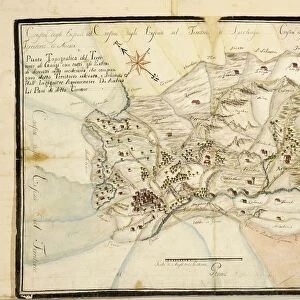
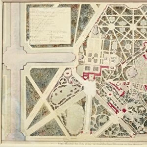
Map of Villa Contarini at Piazzola sul Brenta, Padua province, courtyards and gardens around the Villa

![]()
Wall Art and Photo Gifts from Universal Images Group (UIG)
Map of Villa Contarini at Piazzola sul Brenta, Padua province, courtyards and gardens around the Villa
Cartography, Italy, 17th century. Map of Villa Contarini at Piazzola sul Brenta, Padua province. Courtyards and gardens around the Villa
Universal Images Group (UIG) manages distribution for many leading specialist agencies worldwide
Media ID 9504679
© DEA / A. DAGLI ORTI
Agriculture Courtyard Garden Italian Culture Piazzola Sul Brenta Plan Planning Veneto Villa Villa Contarini Western Script Padua Province
FEATURES IN THESE COLLECTIONS
> Europe
> Italy
> Sculptures
> Europe
> Italy
> Veneto
> Padua
> Universal Images Group (UIG)
> Art
> Painting, Sculpture & Prints
> Cartography
MADE IN THE USA
Safe Shipping with 30 Day Money Back Guarantee
FREE PERSONALISATION*
We are proud to offer a range of customisation features including Personalised Captions, Color Filters and Picture Zoom Tools
SECURE PAYMENTS
We happily accept a wide range of payment options so you can pay for the things you need in the way that is most convenient for you
* Options may vary by product and licensing agreement. Zoomed Pictures can be adjusted in the Cart.