Home > Arts > Artists > M > Sebastian Munster
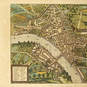
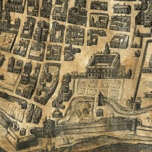
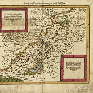
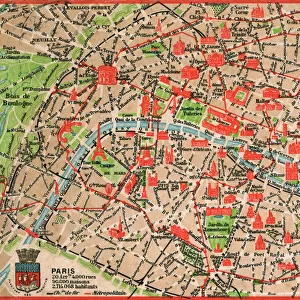
Paris city plan, by Sebastian Munster, 1530

![]()
Wall Art and Photo Gifts from Universal Images Group (UIG)
Paris city plan, by Sebastian Munster, 1530
Cartography, France, 16th century - Paris city plan, 1530, by Sebastian Munster
Universal Images Group (UIG) manages distribution for many leading specialist agencies worldwide
Media ID 9571619
© DEA / G. DAGLI ORTI
16th Century Capital Cities City Ile De France Paris Plan River Seine River Western Script Sebastian Munster
FEATURES IN THESE COLLECTIONS
> Architecture
> Country
> France
> Arts
> Artists
> M
> Sebastian Munster
> Arts
> Landscape paintings
> Waterfall and river artworks
> River artworks
> Europe
> France
> Paris
> Maps
> Europe
> France
> Paris
> River Seine
> Universal Images Group (UIG)
> Art
> Painting, Sculpture & Prints
> Cartography
EDITORS COMMENTS
This print showcases the intricate Paris city plan created by Sebastian Munster in 1530. Munster, a renowned cartographer of the 16th century, meticulously crafted this detailed map that beautifully captures the essence of France's capital city during that era. The full-length studio shot highlights every aspect of this historical masterpiece. The plan itself is a true work of art, showcasing the architectural wonders and layout of Paris in stunning detail. It provides an invaluable glimpse into the past, allowing us to explore the city as it existed centuries ago. The horizontal composition emphasizes the grandeur of Paris and its iconic Seine River flowing through its heart. The absence of people in this image allows us to focus solely on appreciating Munster's skillful illustration and painting techniques. Displayed with Western script annotations, this print serves as both a valuable historical artifact and a testament to Munster's expertise in cartography. Its inclusion within Universal Images Group (UIG) collection ensures its preservation for generations to come. Whether you are an enthusiast of history or simply captivated by maps and architecture, this print offers a unique opportunity to immerse yourself in the rich heritage and beauty of Paris during one of its most transformative periods – all from the comfort of your own space.
MADE IN THE USA
Safe Shipping with 30 Day Money Back Guarantee
FREE PERSONALISATION*
We are proud to offer a range of customisation features including Personalised Captions, Color Filters and Picture Zoom Tools
SECURE PAYMENTS
We happily accept a wide range of payment options so you can pay for the things you need in the way that is most convenient for you
* Options may vary by product and licensing agreement. Zoomed Pictures can be adjusted in the Cart.