Home > Europe > Italy > Emilia-Romagna > Bologna
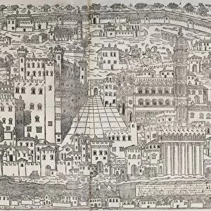
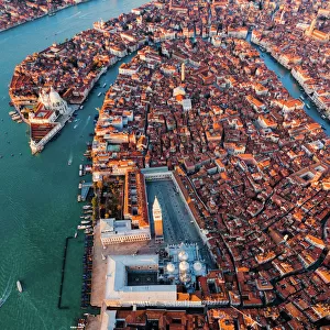
Perspective plan of Bologna from Bononia Alma Studiorum Mater, 1575

![]()
Wall Art and Photo Gifts from Universal Images Group (UIG)
Perspective plan of Bologna from Bononia Alma Studiorum Mater, 1575
Cartography, Italy, 16th century. Perspective plan of Bologna. From Bononia Alma Studiorum Mater, 1575
Universal Images Group (UIG) manages distribution for many leading specialist agencies worldwide
Media ID 9505583
© DEA / A. VILLANI
1575 16th Century Aerial View Bologna City Cityscape Connection Direction Dress Formal Guidance Human Settlement Navigational Equipment Old Fashioned Road Text Two People Western Script
FEATURES IN THESE COLLECTIONS
> Architecture
> Country
> Italy
> Related Images
> Europe
> Italy
> Aerial Views
> Europe
> Italy
> Emilia-Romagna
> Bologna
> Europe
> Italy
> Sculptures
> Universal Images Group (UIG)
> Art
> Painting, Sculpture & Prints
> Cartography
EDITORS COMMENTS
This print takes us back to the 16th century, offering a unique perspective plan of Bologna, Italy. From the renowned Bononia Alma Studiorum Mater publication in 1575, this piece of cartography showcases the city's topography and architectural grandeur with incredible detail. In this full-length image, we are transported to a bygone era where two men and women stand amidst the formal road network that connects various parts of Bologna. The old-fashioned attire they wear adds an authentic touch to the scene, reminding us of the rich history embedded within these streets. The aerial view allows us to appreciate the cityscape from above, revealing its intricate layout and well-preserved buildings. As our eyes wander across this horizontal artwork, we can't help but marvel at how human settlement has evolved over time. The navigational equipment depicted on this map serves as a reminder of how people relied on such tools for guidance during their travels centuries ago. Western script text accompanies specific locations on the map, providing additional information about Bologna's landmarks and points of interest. As we delve into this artful illustration and painting, it becomes evident that it holds immense historical significance. It offers not only a glimpse into Bologna's past but also serves as a testament to the craftsmanship involved in creating such detailed maps during that era. This print is truly a remarkable piece that transports us through time while celebrating both artistry and cartographic expertise.
MADE IN THE USA
Safe Shipping with 30 Day Money Back Guarantee
FREE PERSONALISATION*
We are proud to offer a range of customisation features including Personalised Captions, Color Filters and Picture Zoom Tools
SECURE PAYMENTS
We happily accept a wide range of payment options so you can pay for the things you need in the way that is most convenient for you
* Options may vary by product and licensing agreement. Zoomed Pictures can be adjusted in the Cart.