Home > Arts > Artists > B > Willem Blaeu
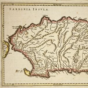
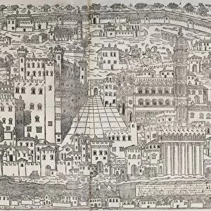
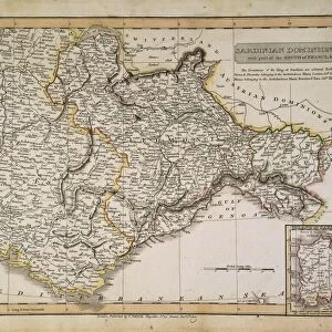
Map of The confines of Siena from Regionum Italiae by Willem Blaeu, engraving

![]()
Wall Art and Photo Gifts from Universal Images Group (UIG)
Map of The confines of Siena from Regionum Italiae by Willem Blaeu, engraving
Cartography, Italy, 17th century. The confines of Siena. From Regionum Italiae by Willem Blaeu. Engraving
Universal Images Group (UIG) manages distribution for many leading specialist agencies worldwide
Media ID 9504477
© DEA / A. DAGLI ORTI
17th Century Aerial View Border Coastline Guidance Human Settlement Nautical Vessel Navigational Equipment Ship Siena Text Tuscany Willem Blaeu Non Urban Scene
FEATURES IN THESE COLLECTIONS
> Arts
> Art Movements
> Landscapes
> Arts
> Artists
> B
> Willem Blaeu
> Arts
> Contemporary art
> Landscapes
> Sculptures
> Arts
> Contemporary art
> Sculpture
> Landscape paintings
> Arts
> Landscape paintings
> Landscape art
> Landscape paintings
> Arts
> Landscape paintings
> Landscape art
> Nature-inspired artwork
> Arts
> Landscape paintings
> Landscape art
> Arts
> Landscape paintings
> Nature-inspired artwork
> Universal Images Group (UIG)
> Art
> Painting, Sculpture & Prints
> Cartography
EDITORS COMMENTS
This print showcases a remarkable piece of cartography from the 17th century. The Map of The confines of Siena, crafted by the talented Willem Blaeu, takes us on a journey through the enchanting landscapes of Tuscany, Italy. With intricate details and precise topography, this engraving offers a glimpse into history and serves as a valuable navigational tool. The aerial view depicted in this horizontal artwork allows us to marvel at the natural beauty that surrounds Siena. From lush green hills to meandering rivers and even glimpses of the sparkling sea, every element is meticulously captured with artistic finesse. As we explore this map further, our eyes are drawn to human settlements along the coastline and beyond - evidence of past civilizations that once thrived in these lands. With its rich historical context and expert craftsmanship, this print not only serves as an exquisite piece of art but also provides invaluable guidance for travelers seeking to navigate through Tuscany's diverse terrain. It reminds us of how maps have been instrumental in shaping our understanding of geography throughout time. Whether you're an admirer of fine art or a curious traveler yearning for knowledge about ancient landscapes, this Map of The confines of Siena will transport you back in time while igniting your sense of adventure.
MADE IN THE USA
Safe Shipping with 30 Day Money Back Guarantee
FREE PERSONALISATION*
We are proud to offer a range of customisation features including Personalised Captions, Color Filters and Picture Zoom Tools
SECURE PAYMENTS
We happily accept a wide range of payment options so you can pay for the things you need in the way that is most convenient for you
* Options may vary by product and licensing agreement. Zoomed Pictures can be adjusted in the Cart.