Home > Arts > Artists > B > Joan Blaeu
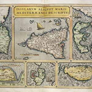
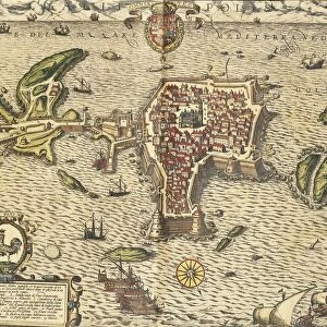
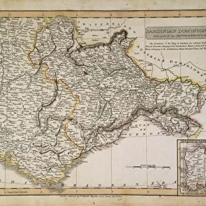
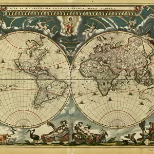
Map of Sardinia region, by Joan Blaeu

![]()
Wall Art and Photo Gifts from Universal Images Group (UIG)
Map of Sardinia region, by Joan Blaeu
Cartography, Italy, 17th century. Map of Sardinia region, by Joan Blaeu
Universal Images Group (UIG) manages distribution for many leading specialist agencies worldwide
Media ID 9571825
© DEA PICTURE LIBRARY
17th Century Coastline Island Italian Culture Joan Blaeu Sardinia Western Script
FEATURES IN THESE COLLECTIONS
> Arts
> Artists
> B
> Joan Blaeu
> Europe
> Italy
> Sardinia
> Related Images
> Europe
> Italy
> Sculptures
> Universal Images Group (UIG)
> Art
> Painting, Sculpture & Prints
> Cartography
EDITORS COMMENTS
This print showcases a remarkable piece of cartographic history - the "Map of Sardinia region" by Joan Blaeu, dating back to the 17th century. With its full length and horizontal layout, this studio shot allows us to appreciate every intricate detail of this ancient map. The island of Sardinia is beautifully depicted in this artwork, revealing its physical geography and coastline with precision. Created using Western script, this map not only serves as a navigational tool but also offers insights into Italian culture during that era. Joan Blaeu's expertise in illustration and painting shines through in this masterpiece. The artistry and craftsmanship evident in each stroke make it clear why his maps are highly regarded even today. As we gaze upon this image, we are transported back to a time when cartography was an essential means for exploration and understanding the world around us. This photograph reminds us of the importance of preserving our past and cherishing these historical artifacts. With no people present in the frame, our focus remains solely on the beauty and significance of this antique map. It serves as a testament to human curiosity and ingenuity, capturing a moment frozen in time. This print from Universal Images Group (UIG) invites us to delve into the rich history embedded within maps like these - where art meets science, cultural heritage intertwines with geographical knowledge, all encapsulated within one captivating image.
MADE IN THE USA
Safe Shipping with 30 Day Money Back Guarantee
FREE PERSONALISATION*
We are proud to offer a range of customisation features including Personalised Captions, Color Filters and Picture Zoom Tools
SECURE PAYMENTS
We happily accept a wide range of payment options so you can pay for the things you need in the way that is most convenient for you
* Options may vary by product and licensing agreement. Zoomed Pictures can be adjusted in the Cart.